Kotanopan geodata
Kotanopan (North Sumatra) is a seat of a third-order administrative division; located in Indonesia in Asia/Jakarta (GMT+7) time zone. In our database, there are 407 cities with bigger population. Compared to other cities in Indonesia, 95.7% of cities are located further ↓South; 97.5% of cities are located further →East and 80.4% of cities have lower elevation than Kotanopan. Note1


Kotanopan GPS coordinates[2]
0° 40' 3.288" North, 99° 42' 32.688" East
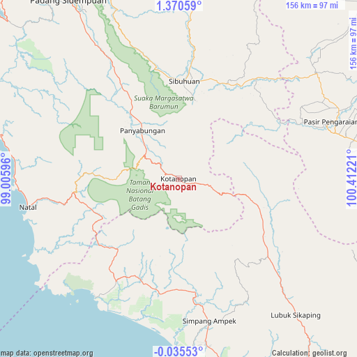
| Map corner | latitude | longitude |
|---|---|---|
| Upper-left | 1.37059°, | 99.00596° |
| Center: | 0.66758°, | 99.70908° |
| Lower-right: | -0.03553°, | 100.41221° |
| Map W x H: | 156.3×156.3 km | = 97.1×97.1mi |
| max Lat: | 5.88969° ⇑4.3% North |
| Kotanopan: | 0.66758° |
| min Lat: | ⇓95.7% South -10.934° |
| min Long | Kotanopan | max Long |
| 95.1345° | 99.70908° | 140.9419° |
| W 2.5%⇐ | ⇒97.5% E |
Elevation
Elevation of Kotanopan is 438 m = 1437 ft, and this is 208.3 m = 683 ft above average elevation for this country.
| Max E: |
3185 m = 10449 ft | 19.6% |
| Kotanopan | 438 m 1437 ft | |
| Avg. | 229.7 m = 754 ft | |
Min E: |
-1 m = -3 ft | 80.4% |
See also: Indonesia elevation on elevation.city.
Geographical zone
Kotanopan is located in North Torrid zone (between Equator and Tropic of Cancer). Distance of Equator is 74.2 km =46.1 mi to South.| Distance of | km | miles | from Kotanopan |
|---|---|---|---|
| North Pole | 9932.8 | 6172 | to North |
| Arctic Circle | 7326.9 | 4552.7 | to North |
| Tropic Cancer | 2531.7 | 1573.1 | to North |
| Equator | 74.2 | 46.1 | to South |


Nearby cities:
15 places around Kotanopan: (largest is in red/bold)
• Air Bangis
63.4 km =39.4 mi,  215°
215°
• Dalududalu
75.3 km =46.8 mi,  52°
52°
• Muara Sipongi
35.5 km =22.1 mi,  107°
107°
• Muara Soma
38.7 km =24 mi,  273°
273°
• Natal
67.6 km =42 mi,  260°
260°
• Panti
51.3 km =31.9 mi,  131°
131°
• Panyambungan
28 km =17.4 mi,  321°
321°
• Pasarujungbatu
48.8 km =30.3 mi,  33°
33°
• Pasir Pengaraian
68.8 km =42.8 mi,  71°
71°
• Siabu
45.5 km =28.3 mi,  328°
328°
• Sibuhuan
43 km =26.7 mi,  3°
3°
• Simpang Empat
64.7 km =40.2 mi,  168°
168°
• Talu
57.3 km =35.6 mi,  148°
148°
• Ujung Gading
47 km =29.2 mi,  200°
200°
• Ujungbatu
48.6 km =30.2 mi, 31°
Sources, notices
• [Note1] Compared only with cities in Indonesia existing in our database
• [Src1] Map data: © OpenStreetMap contributors (CC-BY-SA)
• [Src2] Other city data from geonames.org with taken over terms of usage.
• [Src3] Geographical zone / Annual Mean Temperature by Robert A. Rohde @ Wikipedia
