Sibolga geodata
Sibolga (North Sumatra) is a populated place; located in Indonesia in Asia/Jakarta (GMT+7) time zone. With population of 79,714 people, there are 161 cities with bigger population in this country. Compared to other cities in Indonesia, 96.9% of cities are located further ↓South; 98.1% of cities are located further →East and 97.2% of cities have higher elevation than Sibolga. Note1


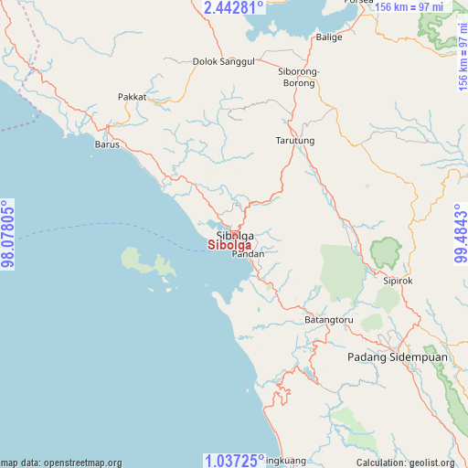
Sibolga GPS coordinates[2]
1° 44' 24.576" North, 98° 46' 52.212" East
| Map corner | latitude | longitude |
|---|---|---|
| Upper-left | 2.44281°, | 98.07805° |
| Center: | 1.74016°, | 98.78117° |
| Lower-right: | 1.03725°, | 99.4843° |
| Map W x H: | 156.3×156.3 km | = 97.1×97.1mi |
| max Lat: | 5.88969° ⇑3.1% North |
| Sibolga: | 1.74016° |
| min Lat: | ⇓96.9% South -10.934° |
| min Long | Sibolga | max Long |
| 95.1345° | 98.78117° | 140.9419° |
| W 1.9%⇐ | ⇒98.1% E |
Elevation
Elevation of Sibolga is 6 m = 20 ft, and this is 223.7 m = 734 ft below average elevation for this country.
| Max E: |
3185 m = 10449 ft | 97.2% |
| Avg. | 229.7 m = 754 ft | |
| Sibolga | 6 m = 20 ft | |
Min E: |
-1 m = -3 ft | 2.8% |
See also: Sibolga elevation on elevation.city.
Geographical zone
Sibolga is located in North Torrid zone (between Equator and Tropic of Cancer). Distance of Equator is 193.5 km =120.2 mi to South.| Distance of | km | miles | from Sibolga |
|---|---|---|---|
| North Pole | 9813.6 | 6097.9 | to North |
| Arctic Circle | 7207.7 | 4478.7 | to North |
| Tropic Cancer | 2412.4 | 1499 | to North |
| Equator | 193.5 | 120.2 | to South |


Nearby cities:
15 places around Sibolga: (largest is in red/bold)
• Barus
52.1 km =32.4 mi,  305°
305°
• Batangtoru
42.7 km =26.5 mi,  132°
132°
• Dolok Sanggul
57.8 km =35.9 mi,  356°
356°
• Lintongnihuta
60.3 km =37.5 mi,  8°
8°
• Onan Ganjang Satu
49.5 km =30.8 mi,  340°
340°
• Pakkat
57.1 km =35.5 mi,  323°
323°
• Pandan
7.7 km =4.8 mi,  144°
144°
• Parmonangan
40.6 km =25.2 mi, 357°
• Sampuran
36.3 km =22.6 mi,  34°
34°
• Sarulla
37.3 km =23.2 mi,  82°
82°
• Siborong-Borong
56.7 km =35.2 mi,  22°
22°
• Sipagimbar
66.4 km =41.3 mi, 81°
• Sipirok
56.8 km =35.3 mi,  105°
105°
• Sipoholon
40.5 km =25.2 mi, 26°
• Tarutung
36.8 km =22.9 mi, 33°
Sources, notices
• [Note1] Compared only with cities in Indonesia existing in our database
• [Src1] Map data: © OpenStreetMap contributors (CC-BY-SA)
• [Src2] Other city data from geonames.org with taken over terms of usage.
• [Src3] Geographical zone / Annual Mean Temperature by Robert A. Rohde @ Wikipedia
