Sarulla geodata
Sarulla (North Sumatra) is a seat of a third-order administrative division; located in Indonesia in Asia/Jakarta (GMT+7) time zone. In our database, there are 407 cities with bigger population. Compared to other cities in Indonesia, 96.9% of cities are located further ↓South; 97.8% of cities are located further →East and 82.4% of cities have lower elevation than Sarulla. Note1


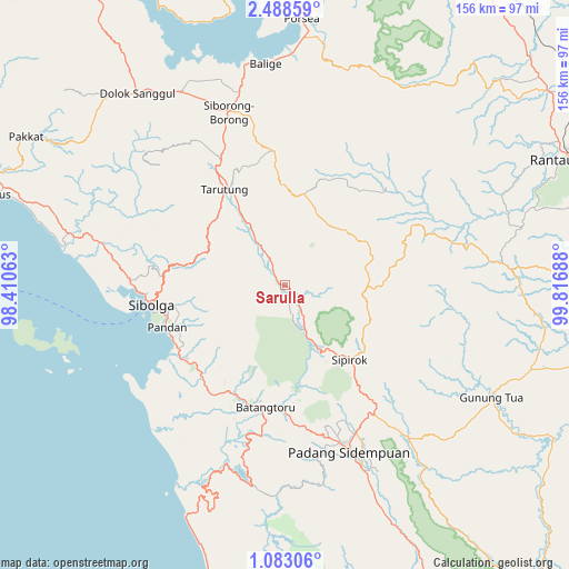
Sarulla GPS coordinates[2]
1° 47' 9.456" North, 99° 6' 49.5" East
| Map corner | latitude | longitude |
|---|---|---|
| Upper-left | 2.48859°, | 98.41063° |
| Center: | 1.78596°, | 99.11375° |
| Lower-right: | 1.08306°, | 99.81688° |
| Map W x H: | 156.3×156.3 km | = 97.1×97.1mi |
| max Lat: | 5.88969° ⇑3.1% North |
| Sarulla: | 1.78596° |
| min Lat: | ⇓96.9% South -10.934° |
| min Long | Sarulla | max Long |
| 95.1345° | 99.11375° | 140.9419° |
| W 2.2%⇐ | ⇒97.8% E |
Elevation
Elevation of Sarulla is 468 m = 1535 ft, and this is 238.3 m = 782 ft above average elevation for this country.
| Max E: |
3185 m = 10449 ft | 17.6% |
| Sarulla | 468 m 1535 ft | |
| Avg. | 229.7 m = 754 ft | |
Min E: |
-1 m = -3 ft | 82.4% |
See also: Indonesia elevation on elevation.city.
Geographical zone
Sarulla is located in North Torrid zone (between Equator and Tropic of Cancer). Distance of Equator is 198.6 km =123.4 mi to South.| Distance of | km | miles | from Sarulla |
|---|---|---|---|
| North Pole | 9808.5 | 6094.7 | to North |
| Arctic Circle | 7202.6 | 4475.5 | to North |
| Tropic Cancer | 2407.3 | 1495.8 | to North |
| Equator | 198.6 | 123.4 | to South |


Nearby cities:
15 places around Sarulla: (largest is in red/bold)
• Balige
61 km =37.9 mi,  354°
354°
• Batangtoru
34.2 km =21.3 mi,  188°
188°
• Gunung Tua
64.6 km =40.1 mi,  118°
118°
• Lintongnihuta
61 km =37.9 mi,  333°
333°
• Padangsidempuan
48.5 km =30.1 mi,  158°
158°
• Pandan
34.4 km =21.4 mi,  250°
250°
• Parmonangan
52.6 km =32.7 mi,  312°
312°
• Sampuran
29.7 km =18.5 mi, 326°
• Sibolga
37.3 km =23.2 mi,  262°
262°
• Siborong-Borong
49.9 km =31 mi,  341°
341°
• Sipagimbar
29.1 km =18.1 mi,  80°
80°
• Sipiongot
61.2 km =38 mi, 84°
• Sipirok
27.1 km =16.8 mi,  138°
138°
• Sipoholon
36.2 km =22.5 mi, 329°
• Tarutung
30.3 km =18.8 mi, 327°
Sources, notices
• [Note1] Compared only with cities in Indonesia existing in our database
• [Src1] Map data: © OpenStreetMap contributors (CC-BY-SA)
• [Src2] Other city data from geonames.org with taken over terms of usage.
• [Src3] Geographical zone / Annual Mean Temperature by Robert A. Rohde @ Wikipedia
