Tarutung geodata
Tarutung (North Sumatra) is a seat of a second-order administrative division; located in Indonesia in Asia/Jakarta (GMT+7) time zone. In our database, there are 407 cities with bigger population. Compared to other cities in Indonesia, 97% of cities are located further ↓South; 97.9% of cities are located further →East and 97% of cities have lower elevation than Tarutung. Note1


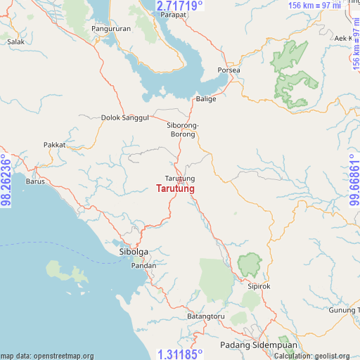
Tarutung GPS coordinates[2]
2° 0' 52.812" North, 98° 57' 55.728" East
| Map corner | latitude | longitude |
|---|---|---|
| Upper-left | 2.71719°, | 98.26236° |
| Center: | 2.01467°, | 98.96548° |
| Lower-right: | 1.31185°, | 99.66861° |
| Map W x H: | 156.3×156.3 km | = 97.1×97.1mi |
| max Lat: | 5.88969° ⇑3% North |
| Tarutung: | 2.01467° |
| min Lat: | ⇓97% South -10.934° |
| min Long | Tarutung | max Long |
| 95.1345° | 98.96548° | 140.9419° |
| W 2.1%⇐ | ⇒97.9% E |
Elevation
Elevation of Tarutung is 948 m = 3110 ft, and this is 718.3 m = 2357 ft above average elevation for this country.
| Max E: |
3185 m = 10449 ft | 3% |
| Tarutung | 948 m 3110 ft | |
| Avg. | 229.7 m = 754 ft | |
Min E: |
-1 m = -3 ft | 97% |
See also: Indonesia elevation on elevation.city.
Geographical zone
Tarutung is located in North Torrid zone (between Equator and Tropic of Cancer). Distance of Equator is 224 km =139.2 mi to South.| Distance of | km | miles | from Tarutung |
|---|---|---|---|
| North Pole | 9783.1 | 6078.9 | to North |
| Arctic Circle | 7177.2 | 4459.7 | to North |
| Tropic Cancer | 2381.9 | 1480 | to North |
| Equator | 224 | 139.2 | to South |


Nearby cities:
15 places around Tarutung: (largest is in red/bold)
• Balige
37.1 km =23.1 mi,  17°
17°
• Dolok Sanggul
36.2 km =22.5 mi,  318°
318°
• Lintongnihuta
31.1 km =19.3 mi,  339°
339°
• Mogang
53.7 km =33.4 mi, 340°
• Muara
36.5 km =22.7 mi,  349°
349°
• Nainggolan
47.7 km =29.6 mi, 349°
• Onan Ganjang Satu
40.5 km =25.2 mi,  293°
293°
• Pandan
40.1 km =24.9 mi,  203°
203°
• Parmonangan
24.5 km =15.2 mi, 294°
• Sampuran
0.7 km =0.4 mi,  169°
169°
• Sarulla
30.3 km =18.8 mi,  147°
147°
• Sibolga
36.8 km =22.9 mi,  213°
213°
• Siborong-Borong
22 km =13.7 mi,  2°
2°
• Sipagimbar
49.6 km =30.8 mi,  114°
114°
• Sipoholon
6 km =3.7 mi, 339°
Sources, notices
• [Note1] Compared only with cities in Indonesia existing in our database
• [Src1] Map data: © OpenStreetMap contributors (CC-BY-SA)
• [Src2] Other city data from geonames.org with taken over terms of usage.
• [Src3] Geographical zone / Annual Mean Temperature by Robert A. Rohde @ Wikipedia
