Tanjungtiram geodata
Tanjungtiram (North Sumatra) is a populated place; located in Indonesia in Asia/Jakarta (GMT+7) time zone. With population of 25,118 people, there are 352 cities with bigger population in this country. Compared to other cities in Indonesia, 98.8% of cities are located further ↓South; 98.3% of cities are located further →East and 99.7% of cities have higher elevation than Tanjungtiram. Note1


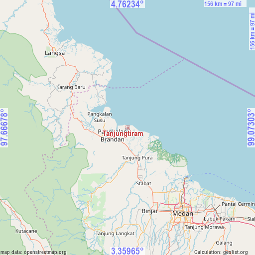
Tanjungtiram GPS coordinates[2]
4° 3' 40.68" North, 98° 22' 11.64" East
| Map corner | latitude | longitude |
|---|---|---|
| Upper-left | 4.76234°, | 97.66678° |
| Center: | 4.0613°, | 98.3699° |
| Lower-right: | 3.35965°, | 99.07303° |
| Map W x H: | 156×156 km | = 96.9×96.9mi |
| max Lat: | 5.88969° ⇑1.2% North |
| Tanjungtiram: | 4.0613° |
| min Lat: | ⇓98.8% South -10.934° |
| min Long | Tanjungtiram | max Long |
| 95.1345° | 98.3699° | 140.9419° |
| W 1.7%⇐ | ⇒98.3% E |
Elevation
Elevation of Tanjungtiram is 2 m = 7 ft, and this is 227.7 m = 747 ft below average elevation for this country.
| Max E: |
3185 m = 10449 ft | 99.7% |
| Avg. | 229.7 m = 754 ft | |
| Tanjungtiram | 2 m = 7 ft | |
Min E: |
-1 m = -3 ft | 0.3% |
See also: Indonesia elevation on elevation.city.
Geographical zone
Tanjungtiram is located in North Torrid zone (between Equator and Tropic of Cancer). Distance of Equator is 451.6 km =280.6 mi to South.| Distance of | km | miles | from Tanjungtiram |
|---|---|---|---|
| North Pole | 9555.5 | 5937.5 | to North |
| Arctic Circle | 6949.6 | 4318.3 | to North |
| Tropic Cancer | 2154.3 | 1338.6 | to North |
| Equator | 451.6 | 280.6 | to South |


Nearby cities:
15 places around Tanjungtiram: (largest is in red/bold)
• Belawan
47.1 km =29.3 mi,  132°
132°
• Binjai
52.9 km =32.9 mi,  165°
165°
• Karangbaru
46.7 km =29 mi,  305°
305°
• Labuhan Deli
50.1 km =31.1 mi,  137°
137°
• Langsa
63.5 km =39.5 mi,  315°
315°
• Medan
62.5 km =38.8 mi,  148°
148°
• Pangkalan Brandan
11 km =6.8 mi,  247°
247°
• Pulau Tiga
55.1 km =34.2 mi,  277°
277°
• Serawai
38.4 km =23.9 mi,  328°
328°
• Stabat
37.5 km =23.3 mi, 166°
• Sungai Iyu
46.4 km =28.8 mi, 325°
• Sunggal
60.4 km =37.5 mi, 153°
• Sungi Liput
42.8 km =26.6 mi,  292°
292°
• Tenggulun
41 km =25.5 mi,  259°
259°
• Tualangcut
50.2 km =31.2 mi, 318°
Sources, notices
• [Note1] Compared only with cities in Indonesia existing in our database
• [Src1] Map data: © OpenStreetMap contributors (CC-BY-SA)
• [Src2] Other city data from geonames.org with taken over terms of usage.
• [Src3] Geographical zone / Annual Mean Temperature by Robert A. Rohde @ Wikipedia
