Wureh geodata
Wureh (East Nusa Tenggara) is a seat of a fourth-order administrative division; located in Indonesia in Asia/Makassar (GMT+8) time zone. In our database, there are 407 cities with bigger population. Compared to other cities in Indonesia, 77% of cities are located further ↑North; 90.5% of cities are located further ←West and 87.7% of cities have higher elevation than Wureh. Note1


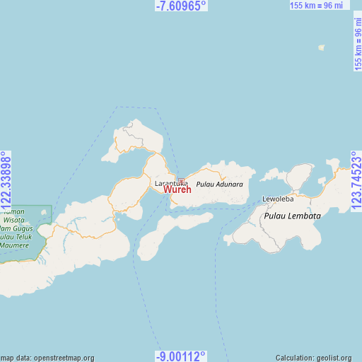
Wureh GPS coordinates[2]
8° 18' 21.6" South, 123° 2' 31.56" East
| Map corner | latitude | longitude |
|---|---|---|
| Upper-left | -7.60965°, | 122.33898° |
| Center: | -8.306°, | 123.0421° |
| Lower-right: | -9.00112°, | 123.74523° |
| Map W x H: | 154.7×154.7 km | = 96.1×96.1mi |
| max Lat: | 5.88969° ⇑77% North |
| Wureh: | -8.306° |
| min Lat: | ⇓23% South -10.934° |
| min Long | Wureh | max Long |
| 95.1345° | 123.0421° | 140.9419° |
| W 90.5%⇐ | ⇒9.5% E |
Elevation
Elevation of Wureh is 12 m = 39 ft, and this is 217.7 m = 714 ft below average elevation for this country.
| Max E: |
3185 m = 10449 ft | 87.7% |
| Avg. | 229.7 m = 754 ft | |
| Wureh | 12 m = 39 ft | |
Min E: |
-1 m = -3 ft | 12.3% |
See also: Indonesia elevation on elevation.city.
Geographical zone
Wureh is located in South Torrid zone (between Equator and Tropic of Capricorn). Distance of Equator is 923.5 km =573.8 mi to North.| Distance of | km | miles | from Wureh |
|---|---|---|---|
| Equator | 923.5 | 573.8 | to North |
| Tropic Capricorn | 1682.4 | 1045.4 | to South |
| Antarctic Circle | 6477.6 | 4025 | to South |
| South Pole | 9083.5 | 5644.2 | to South |


Nearby cities:
15 places around Wureh: (largest is in red/bold)
• Amagarapati
6.3 km =3.9 mi,  239°
239°
• Ekasapta
5.5 km =3.4 mi, 239°
• Era
7.9 km =4.9 mi,  106°
106°
• Kanariblolong
3.4 km =2.1 mi,  57°
57°
• Lahayong
7.5 km =4.7 mi, 237°
• Larantuka
5 km =3.1 mi, 241°
• Lebao
4.4 km =2.7 mi, 243°
• Lokea
7.3 km =4.5 mi, 237°
• Pohonsirih
7.8 km =4.8 mi, 237°
• Postoh
6.8 km =4.2 mi, 237°
• Tabali
3.3 km =2.1 mi,  246°
246°
• Waiwadan
6.5 km =4 mi, 59°
• Watodei
7.1 km =4.4 mi,  120°
120°
• Watowiti
5.6 km =3.5 mi,  305°
305°
• Wayangona
6.2 km =3.9 mi,  150°
150°
Sources, notices
• [Note1] Compared only with cities in Indonesia existing in our database
• [Src1] Map data: © OpenStreetMap contributors (CC-BY-SA)
• [Src2] Other city data from geonames.org with taken over terms of usage.
• [Src3] Geographical zone / Annual Mean Temperature by Robert A. Rohde @ Wikipedia
