Cirebon geodata
Cirebon (West Java) is a populated place; located in Indonesia in Asia/Jakarta (GMT+7) time zone. With population of 254,298 people, there are 39 cities with bigger population in this country. Compared to other cities in Indonesia, 80.4% of cities are located further ↓South; 70.8% of cities are located further →East and 93.7% of cities have higher elevation than Cirebon. Note1


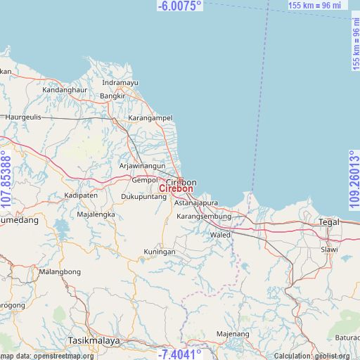
Cirebon GPS coordinates[2]
6° 42' 22.68" South, 108° 33' 25.2" East
| Map corner | latitude | longitude |
|---|---|---|
| Upper-left | -6.0075°, | 107.85388° |
| Center: | -6.7063°, | 108.557° |
| Lower-right: | -7.4041°, | 109.26013° |
| Map W x H: | 155.3×155.3 km | = 96.5×96.5mi |
| max Lat: | 5.88969° ⇑19.6% North |
| Cirebon: | -6.7063° |
| min Lat: | ⇓80.4% South -10.934° |
| min Long | Cirebon | max Long |
| 95.1345° | 108.557° | 140.9419° |
| W 29.2%⇐ | ⇒70.8% E |
Elevation
Elevation of Cirebon is 8 m = 26 ft, and this is 221.7 m = 727 ft below average elevation for this country.
| Max E: |
3185 m = 10449 ft | 93.7% |
| Avg. | 229.7 m = 754 ft | |
| Cirebon | 8 m = 26 ft | |
Min E: |
-1 m = -3 ft | 6.3% |
See also: Cirebon elevation on elevation.city.
Geographical zone
Cirebon is located in South Torrid zone (between Equator and Tropic of Capricorn). Distance of Equator is 745.7 km =463.4 mi to North.| Distance of | km | miles | from Cirebon |
|---|---|---|---|
| Equator | 745.7 | 463.4 | to North |
| Tropic Capricorn | 1860.2 | 1155.9 | to South |
| Antarctic Circle | 6655.5 | 4135.5 | to South |
| South Pole | 9261.4 | 5754.8 | to South |


Nearby cities:
15 places around Cirebon: (largest is in red/bold)
• Arjawinangun
17.6 km =10.9 mi,  292°
292°
• Astanajapura
13.4 km =8.3 mi,  142°
142°
• Garawangi
32.6 km =20.3 mi,  183°
183°
• Jatiwangi
32.6 km =20.3 mi,  264°
264°
• Karangampel
29.5 km =18.3 mi,  336°
336°
• Karangsembung
18.4 km =11.4 mi,  149°
149°
• Klangenan
12.9 km =8 mi,  268°
268°
• Kuningan
31.1 km =19.3 mi,  195°
195°
• Olejet
31.8 km =19.8 mi, 177°
• Palimanan
14.7 km =9.1 mi, 269°
• Plumbon
9.3 km =5.8 mi, 270°
• Sindang
32.8 km =20.4 mi, 175°
• Sukaimut
33.2 km =20.6 mi, 182°
• Sumber
10.1 km =6.3 mi,  233°
233°
• Weru
5.9 km =3.7 mi, 264°
Sources, notices
• [Note1] Compared only with cities in Indonesia existing in our database
• [Src1] Map data: © OpenStreetMap contributors (CC-BY-SA)
• [Src2] Other city data from geonames.org with taken over terms of usage.
• [Src3] Geographical zone / Annual Mean Temperature by Robert A. Rohde @ Wikipedia
