Sidareja geodata
Sidareja (Central Java) is a seat of a third-order administrative division; located in Indonesia in Asia/Jakarta (GMT+7) time zone. With population of 30,313 people, there are 312 cities with bigger population in this country. Compared to other cities in Indonesia, 55.4% of cities are located further ↑North; 67.8% of cities are located further →East and 93.7% of cities have higher elevation than Sidareja. Note1


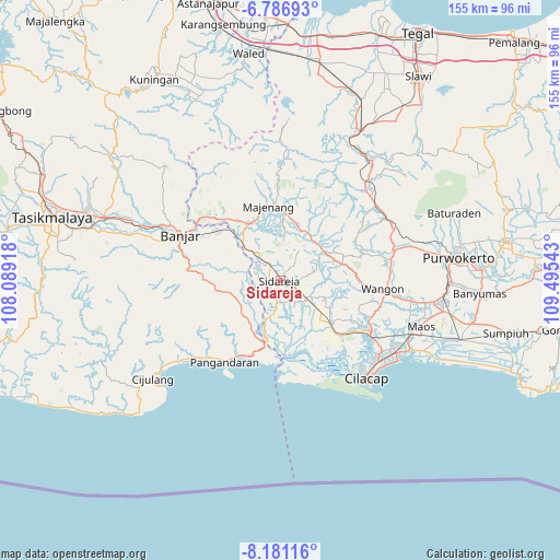
Sidareja GPS coordinates[2]
7° 29' 4.56" South, 108° 47' 32.28" East
| Map corner | latitude | longitude |
|---|---|---|
| Upper-left | -6.78693°, | 108.08918° |
| Center: | -7.4846°, | 108.7923° |
| Lower-right: | -8.18116°, | 109.49543° |
| Map W x H: | 155×155 km | = 96.3×96.3mi |
| max Lat: | 5.88969° ⇑55.4% North |
| Sidareja: | -7.4846° |
| min Lat: | ⇓44.6% South -10.934° |
| min Long | Sidareja | max Long |
| 95.1345° | 108.7923° | 140.9419° |
| W 32.2%⇐ | ⇒67.8% E |
Elevation
Elevation of Sidareja is 8 m = 26 ft, and this is 221.7 m = 727 ft below average elevation for this country.
| Max E: |
3185 m = 10449 ft | 93.7% |
| Avg. | 229.7 m = 754 ft | |
| Sidareja | 8 m = 26 ft | |
Min E: |
-1 m = -3 ft | 6.3% |
See also: Indonesia elevation on elevation.city.
Geographical zone
Sidareja is located in South Torrid zone (between Equator and Tropic of Capricorn). Distance of Equator is 832.2 km =517.1 mi to North.| Distance of | km | miles | from Sidareja |
|---|---|---|---|
| Equator | 832.2 | 517.1 | to North |
| Tropic Capricorn | 1773.7 | 1102.1 | to South |
| Antarctic Circle | 6569 | 4081.8 | to South |
| South Pole | 9174.9 | 5701 | to South |


Nearby cities:
15 places around Sidareja: (largest is in red/bold)
• Cikalong
0.4 km =0.2 mi,  356°
356°
• Ciklapa
3.3 km =2.1 mi,  149°
149°
• Cikondang
2.2 km =1.4 mi,  56°
56°
• Cipariuk
3.2 km =2 mi,  235°
235°
• Citengah
1.7 km =1.1 mi,  268°
268°
• Dukuhtengah
3.8 km =2.4 mi,  165°
165°
• Gendiwu
2.2 km =1.4 mi,  105°
105°
• Kauman
0.8 km =0.5 mi,  307°
307°
• Kedungbakung
3.1 km =1.9 mi,  222°
222°
• Kedungreja
2.6 km =1.6 mi,  211°
211°
• Kedungwringin
2.8 km =1.7 mi,  287°
287°
• Mulyosari
2.6 km =1.6 mi,  195°
195°
• Prumpung
4 km =2.5 mi, 306°
• Sidamulya
1.4 km =0.9 mi, 107°
• Tambangan
3.2 km =2 mi,  92°
92°
Sources, notices
• [Note1] Compared only with cities in Indonesia existing in our database
• [Src1] Map data: © OpenStreetMap contributors (CC-BY-SA)
• [Src2] Other city data from geonames.org with taken over terms of usage.
• [Src3] Geographical zone / Annual Mean Temperature by Robert A. Rohde @ Wikipedia
