Kedungbakung geodata
Kedungbakung (Central Java) is a seat of a fourth-order administrative division; located in Indonesia in Asia/Jakarta (GMT+7) time zone. In our database, there are 407 cities with bigger population. Compared to other cities in Indonesia, 56% of cities are located further ↑North; 68% of cities are located further →East and 86.4% of cities have higher elevation than Kedungbakung. Note1


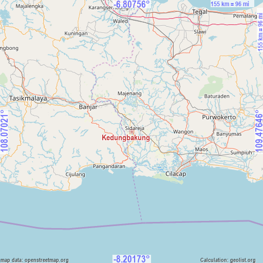
Kedungbakung GPS coordinates[2]
7° 30' 18.72" South, 108° 46' 23.988" East
| Map corner | latitude | longitude |
|---|---|---|
| Upper-left | -6.80756°, | 108.07021° |
| Center: | -7.5052°, | 108.77333° |
| Lower-right: | -8.20173°, | 109.47646° |
| Map W x H: | 155×155 km | = 96.3×96.3mi |
| max Lat: | 5.88969° ⇑56% North |
| Kedungbakung: | -7.5052° |
| min Lat: | ⇓44% South -10.934° |
| min Long | Kedungbakung | max Long |
| 95.1345° | 108.77333° | 140.9419° |
| W 32%⇐ | ⇒68% E |
Elevation
Elevation of Kedungbakung is 13 m = 43 ft, and this is 216.7 m = 711 ft below average elevation for this country.
| Max E: |
3185 m = 10449 ft | 86.4% |
| Avg. | 229.7 m = 754 ft | |
| Kedungbakung | 13 m = 43 ft | |
Min E: |
-1 m = -3 ft | 13.6% |
See also: Indonesia elevation on elevation.city.
Geographical zone
Kedungbakung is located in South Torrid zone (between Equator and Tropic of Capricorn). Distance of Equator is 834.5 km =518.5 mi to North.| Distance of | km | miles | from Kedungbakung |
|---|---|---|---|
| Equator | 834.5 | 518.5 | to North |
| Tropic Capricorn | 1771.4 | 1100.7 | to South |
| Antarctic Circle | 6566.7 | 4080.4 | to South |
| South Pole | 9172.6 | 5699.6 | to South |


Nearby cities:
15 places around Kedungbakung: (largest is in red/bold)
• Cikalong
3.4 km =2.1 mi,  37°
37°
• Ciklapa
3.8 km =2.4 mi,  97°
97°
• Cipariuk
0.7 km =0.4 mi,  312°
312°
• Citengah
2.3 km =1.4 mi,  9°
9°
• Dukuhtengah
3.3 km =2.1 mi,  114°
114°
• Gendiwu
4.5 km =2.8 mi,  67°
67°
• Kauman
3.1 km =1.9 mi,  27°
27°
• Kedungbulu
3.8 km =2.4 mi,  162°
162°
• Kedungreja
0.7 km =0.4 mi,  85°
85°
• Kedungwringin
3.2 km =2 mi,  349°
349°
• Mulyosari
1.4 km =0.9 mi, 99°
• Rejamulya
4.6 km =2.9 mi, 309°
• Sidamulya
3.9 km =2.4 mi,  61°
61°
• Sidareja
3.1 km =1.9 mi, 42°
• Tambaksari
2.5 km =1.6 mi,  280°
280°
Sources, notices
• [Note1] Compared only with cities in Indonesia existing in our database
• [Src1] Map data: © OpenStreetMap contributors (CC-BY-SA)
• [Src2] Other city data from geonames.org with taken over terms of usage.
• [Src3] Geographical zone / Annual Mean Temperature by Robert A. Rohde @ Wikipedia
