Selogiri geodata
Selogiri (Central Java) is a populated place; located in Indonesia in Asia/Jakarta (GMT+7) time zone. With population of 30,180 people, there are 314 cities with bigger population in this country. Compared to other cities in Indonesia, 60.8% of cities are located further ↑North; 65.1% of cities are located further →East and 53.6% of cities have lower elevation than Selogiri. Note1


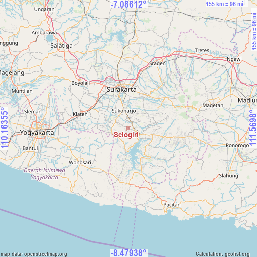
Selogiri GPS coordinates[2]
7° 46' 59.988" South, 110° 52' 0.012" East
| Map corner | latitude | longitude |
|---|---|---|
| Upper-left | -7.08612°, | 110.16355° |
| Center: | -7.78333°, | 110.86667° |
| Lower-right: | -8.47938°, | 111.5698° |
| Map W x H: | 154.9×154.9 km | = 96.3×96.3mi |
| max Lat: | 5.88969° ⇑60.8% North |
| Selogiri: | -7.78333° |
| min Lat: | ⇓39.2% South -10.934° |
| min Long | Selogiri | max Long |
| 95.1345° | 110.86667° | 140.9419° |
| W 34.9%⇐ | ⇒65.1% E |
Elevation
Elevation of Selogiri is 117 m = 384 ft, and this is 112.7 m = 370 ft below average elevation for this country.
| Max E: |
3185 m = 10449 ft | 46.4% |
| Avg. | 229.7 m = 754 ft | |
| Selogiri | 117 m = 384 ft | |
Min E: |
-1 m = -3 ft | 53.6% |
See also: Indonesia elevation on elevation.city.
Geographical zone
Selogiri is located in South Torrid zone (between Equator and Tropic of Capricorn). Distance of Equator is 865.4 km =537.7 mi to North.| Distance of | km | miles | from Selogiri |
|---|---|---|---|
| Equator | 865.4 | 537.7 | to North |
| Tropic Capricorn | 1740.5 | 1081.5 | to South |
| Antarctic Circle | 6535.7 | 4061.1 | to South |
| South Pole | 9141.6 | 5680.3 | to South |


Nearby cities:
15 places around Selogiri: (largest is in red/bold)
• Baki
21 km =13 mi,  334°
334°
• Ceper
24 km =14.9 mi,  300°
300°
• Delanggu
27.4 km =17 mi,  312°
312°
• Gatak
27.9 km =17.3 mi,  320°
320°
• Grogol
20.9 km =13 mi,  345°
345°
• Jaten
23.2 km =14.4 mi,  8°
8°
• Jatiroto
29.7 km =18.5 mi,  111°
111°
• Karanganom
30.5 km =19 mi, 299°
• Karanganyar
22.3 km =13.9 mi,  22°
22°
• Kartasura
29.4 km =18.3 mi, 331°
• Klaten
29.9 km =18.6 mi,  286°
286°
• Sukoharjo
12.7 km =7.9 mi, 345°
• Surakarta
25.6 km =15.9 mi, 351°
• Trucuk
24 km =14.9 mi, 287°
• Wonogiri
6.9 km =4.3 mi,  120°
120°
Sources, notices
• [Note1] Compared only with cities in Indonesia existing in our database
• [Src1] Map data: © OpenStreetMap contributors (CC-BY-SA)
• [Src2] Other city data from geonames.org with taken over terms of usage.
• [Src3] Geographical zone / Annual Mean Temperature by Robert A. Rohde @ Wikipedia
