Jatiroto geodata
Jatiroto (Central Java) is a populated place; located in Indonesia in Asia/Jakarta (GMT+7) time zone. With population of 50,059 people, there are 231 cities with bigger population in this country. Compared to other cities in Indonesia, 61.1% of cities are located further ↑North; 63.4% of cities are located further →East and 68.2% of cities have lower elevation than Jatiroto. Note1


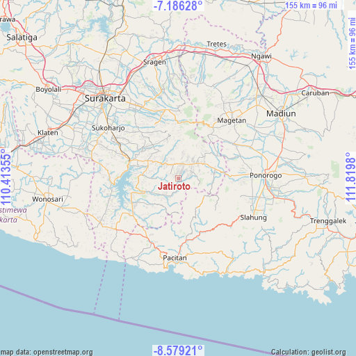
Jatiroto GPS coordinates[2]
7° 52' 59.988" South, 111° 7' 0.012" East
| Map corner | latitude | longitude |
|---|---|---|
| Upper-left | -7.18628°, | 110.41355° |
| Center: | -7.88333°, | 111.11667° |
| Lower-right: | -8.57921°, | 111.8198° |
| Map W x H: | 154.9×154.9 km | = 96.3×96.3mi |
| max Lat: | 5.88969° ⇑61.1% North |
| Jatiroto: | -7.88333° |
| min Lat: | ⇓38.9% South -10.934° |
| min Long | Jatiroto | max Long |
| 95.1345° | 111.11667° | 140.9419° |
| W 36.6%⇐ | ⇒63.4% E |
Elevation
Elevation of Jatiroto is 265 m = 869 ft, and this is 35.3 m = 116 ft above average elevation for this country.
| Max E: |
3185 m = 10449 ft | 31.8% |
| Jatiroto | 265 m 869 ft | |
| Avg. | 229.7 m = 754 ft | |
Min E: |
-1 m = -3 ft | 68.2% |
See also: Jatiroto elevation on elevation.city.
Geographical zone
Jatiroto is located in South Torrid zone (between Equator and Tropic of Capricorn). Distance of Equator is 876.5 km =544.6 mi to North.| Distance of | km | miles | from Jatiroto |
|---|---|---|---|
| Equator | 876.5 | 544.6 | to North |
| Tropic Capricorn | 1729.4 | 1074.6 | to South |
| Antarctic Circle | 6524.6 | 4054.2 | to South |
| South Pole | 9130.5 | 5673.4 | to South |


Nearby cities:
15 places around Jatiroto: (largest is in red/bold)
• Banggel
36.1 km =22.4 mi,  111°
111°
• Broto
35.7 km =22.2 mi,  115°
115°
• Krajan
27.8 km =17.3 mi,  200°
200°
• Krajan Caluk
35.4 km =22 mi, 119°
• Krajan Menggare
36.1 km =22.4 mi, 113°
• Krajan Senepo
35.3 km =21.9 mi, 120°
• Krajan Tengah
32.5 km =20.2 mi, 117°
• Krajan Tugurejo
34.5 km =21.4 mi, 119°
• Magetan
34.6 km =21.5 mi,  43°
43°
• Maron
36.2 km =22.5 mi, 112°
• Melikan
35.5 km =22.1 mi, 112°
• Pacitan
34.6 km =21.5 mi,  182°
182°
• Ploso
23 km =14.3 mi, 195°
• Selogiri
29.7 km =18.5 mi,  291°
291°
• Wonogiri
22.9 km =14.2 mi, 289°
Sources, notices
• [Note1] Compared only with cities in Indonesia existing in our database
• [Src1] Map data: © OpenStreetMap contributors (CC-BY-SA)
• [Src2] Other city data from geonames.org with taken over terms of usage.
• [Src3] Geographical zone / Annual Mean Temperature by Robert A. Rohde @ Wikipedia
