Raduria geodata
Raduria (West Papua) is a seat of a third-order administrative division; located in Indonesia in Asia/Jayapura (GMT+9) time zone. In our database, there are 407 cities with bigger population. Compared to other cities in Indonesia, 91.4% of cities are located further ↓South; 98.9% of cities are located further ←West and 58% of cities have lower elevation than Raduria. Note1


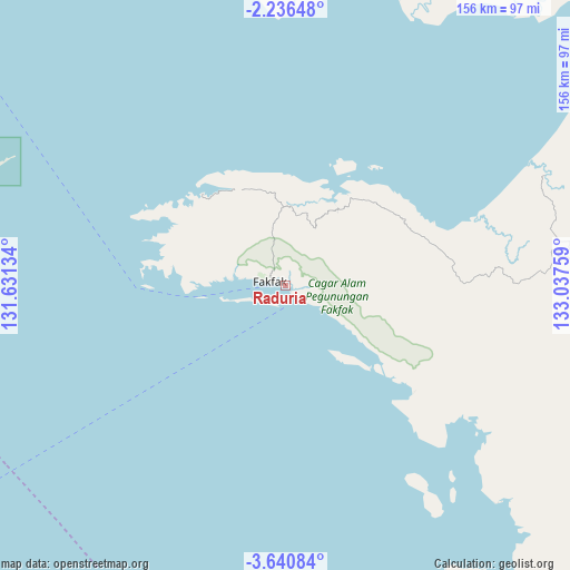
Raduria GPS coordinates[2]
2° 56' 19.968" South, 132° 20' 4.056" East
| Map corner | latitude | longitude |
|---|---|---|
| Upper-left | -2.23648°, | 131.63134° |
| Center: | -2.93888°, | 132.33446° |
| Lower-right: | -3.64084°, | 133.03759° |
| Map W x H: | 156.2×156.2 km | = 97.1×97.1mi |
| max Lat: | 5.88969° ⇑8.6% North |
| Raduria: | -2.93888° |
| min Lat: | ⇓91.4% South -10.934° |
| min Long | Raduria | max Long |
| 95.1345° | 132.33446° | 140.9419° |
| W 98.9%⇐ | ⇒1.1% E |
Elevation
Elevation of Raduria is 146 m = 479 ft, and this is 83.7 m = 275 ft below average elevation for this country.
| Max E: |
3185 m = 10449 ft | 42% |
| Avg. | 229.7 m = 754 ft | |
| Raduria | 146 m = 479 ft | |
Min E: |
-1 m = -3 ft | 58% |
See also: Indonesia elevation on elevation.city.
Geographical zone
Raduria is located in South Torrid zone (between Equator and Tropic of Capricorn). Distance of Equator is 326.8 km =203.1 mi to North.| Distance of | km | miles | from Raduria |
|---|---|---|---|
| Equator | 326.8 | 203.1 | to North |
| Tropic Capricorn | 2279.1 | 1416.2 | to South |
| Antarctic Circle | 7074.4 | 4395.8 | to South |
| South Pole | 9680.3 | 6015.1 | to South |


Nearby cities:
15 places around Raduria: (largest is in red/bold)
• Aitinyo
180.9 km =112.4 mi,  0°
0°
• Ayamaru
185.7 km =115.4 mi,  355°
355°
• Babo
128.5 km =79.8 mi,  69°
69°
• Bintuni
162.4 km =100.9 mi,  55°
55°
• Bofuer
158.8 km =98.7 mi,  92°
92°
• Dulanpokpok
7.1 km =4.4 mi,  281°
281°
• Fakfak
4.3 km =2.7 mi,  291°
291°
• Kaimana
178.1 km =110.7 mi,  116°
116°
• Kokas Kota
28.8 km =17.9 mi,  23°
23°
• Kramongmongga
20.6 km =12.8 mi,  14°
14°
• Merdey
181.2 km =112.6 mi,  38°
38°
• Onimsari
73.5 km =45.7 mi,  83°
83°
• Patipi Pasir
34.1 km =21.2 mi,  317°
317°
• Serkos
92.3 km =57.4 mi,  348°
348°
• Teminabuan
170.2 km =105.8 mi, 347°
Sources, notices
• [Note1] Compared only with cities in Indonesia existing in our database
• [Src1] Map data: © OpenStreetMap contributors (CC-BY-SA)
• [Src2] Other city data from geonames.org with taken over terms of usage.
• [Src3] Geographical zone / Annual Mean Temperature by Robert A. Rohde @ Wikipedia
