Pota geodata
Pota (East Nusa Tenggara) is a seat of a third-order administrative division; located in Indonesia in Asia/Makassar (GMT+8) time zone. In our database, there are 407 cities with bigger population. Compared to other cities in Indonesia, 78.4% of cities are located further ↑North; 85.2% of cities are located further ←West and 90.6% of cities have higher elevation than Pota. Note1


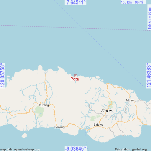
Pota GPS coordinates[2]
8° 20' 29.04" South, 120° 45' 38.52" East
| Map corner | latitude | longitude |
|---|---|---|
| Upper-left | -7.64511°, | 120.05758° |
| Center: | -8.3414°, | 120.7607° |
| Lower-right: | -9.03645°, | 121.46383° |
| Map W x H: | 154.7×154.7 km | = 96.1×96.1mi |
| max Lat: | 5.88969° ⇑78.4% North |
| Pota: | -8.3414° |
| min Lat: | ⇓21.6% South -10.934° |
| min Long | Pota | max Long |
| 95.1345° | 120.7607° | 140.9419° |
| W 85.2%⇐ | ⇒14.8% E |
Elevation
Elevation of Pota is 10 m = 33 ft, and this is 219.7 m = 721 ft below average elevation for this country.
| Max E: |
3185 m = 10449 ft | 90.6% |
| Avg. | 229.7 m = 754 ft | |
| Pota | 10 m = 33 ft | |
Min E: |
-1 m = -3 ft | 9.4% |
See also: Indonesia elevation on elevation.city.
Geographical zone
Pota is located in South Torrid zone (between Equator and Tropic of Capricorn). Distance of Equator is 927.5 km =576.3 mi to North.| Distance of | km | miles | from Pota |
|---|---|---|---|
| Equator | 927.5 | 576.3 | to North |
| Tropic Capricorn | 1678.4 | 1042.9 | to South |
| Antarctic Circle | 6473.7 | 4022.6 | to South |
| South Pole | 9079.6 | 5641.8 | to South |


Nearby cities:
15 places around Pota: (largest is in red/bold)
• Buti
18.8 km =11.7 mi,  198°
198°
• Dampek
18.9 km =11.7 mi,  283°
283°
• Heret
16.2 km =10.1 mi,  243°
243°
• Kembo
14.6 km =9.1 mi,  115°
115°
• Lengkoajang
20.5 km =12.7 mi,  205°
205°
• Lengkorandang
2.7 km =1.7 mi,  103°
103°
• Mombok
20.9 km =13 mi,  189°
189°
• Nao
17.2 km =10.7 mi, 189°
• Rado
17.7 km =11 mi, 213°
• Reweng
21.7 km =13.5 mi,  216°
216°
• Sarae
0.3 km =0.2 mi,  325°
325°
• Waenenda
18.6 km =11.6 mi,  227°
227°
• Waetuwa
17.5 km =10.9 mi,  255°
255°
• Waso
21.6 km =13.4 mi, 242°
• Wera
4.5 km =2.8 mi,  271°
271°
Sources, notices
• [Note1] Compared only with cities in Indonesia existing in our database
• [Src1] Map data: © OpenStreetMap contributors (CC-BY-SA)
• [Src2] Other city data from geonames.org with taken over terms of usage.
• [Src3] Geographical zone / Annual Mean Temperature by Robert A. Rohde @ Wikipedia
