Kembo geodata
Kembo (East Nusa Tenggara) is a seat of a fourth-order administrative division; located in Indonesia in Asia/Makassar (GMT+8) time zone. In our database, there are 407 cities with bigger population. Compared to other cities in Indonesia, 80.3% of cities are located further ↑North; 85.3% of cities are located further ←West and 74.1% of cities have higher elevation than Kembo. Note1


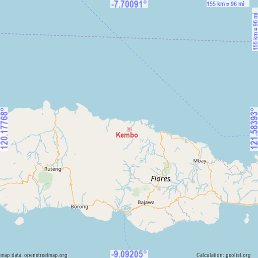
Kembo GPS coordinates[2]
8° 23' 49.56" South, 120° 52' 50.88" East
| Map corner | latitude | longitude |
|---|---|---|
| Upper-left | -7.70091°, | 120.17768° |
| Center: | -8.3971°, | 120.8808° |
| Lower-right: | -9.09205°, | 121.58393° |
| Map W x H: | 154.7×154.7 km | = 96.1×96.1mi |
| max Lat: | 5.88969° ⇑80.3% North |
| Kembo: | -8.3971° |
| min Lat: | ⇓19.7% South -10.934° |
| min Long | Kembo | max Long |
| 95.1345° | 120.8808° | 140.9419° |
| W 85.3%⇐ | ⇒14.7% E |
Elevation
Elevation of Kembo is 26 m = 85 ft, and this is 203.7 m = 668 ft below average elevation for this country.
| Max E: |
3185 m = 10449 ft | 74.1% |
| Avg. | 229.7 m = 754 ft | |
| Kembo | 26 m = 85 ft | |
Min E: |
-1 m = -3 ft | 25.9% |
See also: Indonesia elevation on elevation.city.
Geographical zone
Kembo is located in South Torrid zone (between Equator and Tropic of Capricorn). Distance of Equator is 933.7 km =580.2 mi to North.| Distance of | km | miles | from Kembo |
|---|---|---|---|
| Equator | 933.7 | 580.2 | to North |
| Tropic Capricorn | 1672.2 | 1039.1 | to South |
| Antarctic Circle | 6467.5 | 4018.7 | to South |
| South Pole | 9073.4 | 5637.9 | to South |


Nearby cities:
15 places around Kembo: (largest is in red/bold)
• Buti
22.5 km =14 mi,  238°
238°
• Golokutu
16.4 km =10.2 mi,  101°
101°
• Lengkorandang
12 km =7.5 mi,  297°
297°
• Marolidhong
18.8 km =11.7 mi,  118°
118°
• Mbarungkeli
12.8 km =8 mi,  94°
94°
• Mombok
22.1 km =13.7 mi,  229°
229°
• Nao
19.4 km =12.1 mi, 236°
• Pota
14.6 km =9.1 mi, 295°
• Punsu
16.1 km =10 mi, 98°
• Rado
24.6 km =15.3 mi,  249°
249°
• Rantang
22.7 km =14.1 mi,  222°
222°
• Riung
16.2 km =10.1 mi, 99°
• Sarae
14.8 km =9.2 mi, 295°
• Wate
14.3 km =8.9 mi,  142°
142°
• Wera
18.8 km =11.7 mi,  289°
289°
Sources, notices
• [Note1] Compared only with cities in Indonesia existing in our database
• [Src1] Map data: © OpenStreetMap contributors (CC-BY-SA)
• [Src2] Other city data from geonames.org with taken over terms of usage.
• [Src3] Geographical zone / Annual Mean Temperature by Robert A. Rohde @ Wikipedia
