Polewali geodata
Polewali (West Sulawesi) is a seat of a second-order administrative division; located in Indonesia in Asia/Makassar (GMT+8) time zone. With population of 58,190 people, there are 205 cities with bigger population in this country. Compared to other cities in Indonesia, 90.4% of cities are located further ↓South; 81.4% of cities are located further ←West and 97.2% of cities have higher elevation than Polewali. Note1


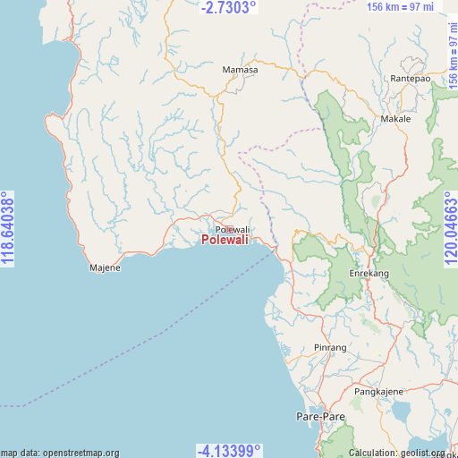
Polewali GPS coordinates[2]
3° 25' 56.64" South, 119° 20' 36.6" East
| Map corner | latitude | longitude |
|---|---|---|
| Upper-left | -2.7303°, | 118.64038° |
| Center: | -3.4324°, | 119.3435° |
| Lower-right: | -4.13399°, | 120.04663° |
| Map W x H: | 156.1×156.1 km | = 97×97mi |
| max Lat: | 5.88969° ⇑9.6% North |
| Polewali: | -3.4324° |
| min Lat: | ⇓90.4% South -10.934° |
| min Long | Polewali | max Long |
| 95.1345° | 119.3435° | 140.9419° |
| W 81.4%⇐ | ⇒18.6% E |
Elevation
Elevation of Polewali is 6 m = 20 ft, and this is 223.7 m = 734 ft below average elevation for this country.
| Max E: |
3185 m = 10449 ft | 97.2% |
| Avg. | 229.7 m = 754 ft | |
| Polewali | 6 m = 20 ft | |
Min E: |
-1 m = -3 ft | 2.8% |
See also: Polewali elevation on elevation.city.
Geographical zone
Polewali is located in South Torrid zone (between Equator and Tropic of Capricorn). Distance of Equator is 381.6 km =237.1 mi to North.| Distance of | km | miles | from Polewali |
|---|---|---|---|
| Equator | 381.6 | 237.1 | to North |
| Tropic Capricorn | 2224.3 | 1382.1 | to South |
| Antarctic Circle | 7019.5 | 4361.7 | to South |
| South Pole | 9625.4 | 5980.9 | to South |


Nearby cities:
15 places around Polewali: (largest is in red/bold)
• Allu
39.1 km =24.3 mi,  271°
271°
• Belajen
54.6 km =33.9 mi,  77°
77°
• Buakayu
49.5 km =30.8 mi,  58°
58°
• Cakke
50.6 km =31.4 mi,  87°
87°
• Cempa Pasar
44.2 km =27.5 mi,  142°
142°
• Enrekang
49.6 km =30.8 mi,  107°
107°
• Galunggalung
50.1 km =31.1 mi,  262°
262°
• Lampa
33.2 km =20.6 mi, 140°
• Langnga
50.1 km =31.1 mi,  156°
156°
• Majene
43.1 km =26.8 mi,  253°
253°
• Mamasa
54.7 km =34 mi,  3°
3°
• Petoosang
39.2 km =24.4 mi, 270°
• Pinrang
52.2 km =32.4 mi, 138°
• Somba
55.4 km =34.4 mi,  276°
276°
• Teppo
47.3 km =29.4 mi,  130°
130°
Sources, notices
• [Note1] Compared only with cities in Indonesia existing in our database
• [Src1] Map data: © OpenStreetMap contributors (CC-BY-SA)
• [Src2] Other city data from geonames.org with taken over terms of usage.
• [Src3] Geographical zone / Annual Mean Temperature by Robert A. Rohde @ Wikipedia
