Majene geodata
Majene (West Sulawesi) is a seat of a second-order administrative division; located in Indonesia in Asia/Makassar (GMT+8) time zone. With population of 37,715 people, there are 279 cities with bigger population in this country. Compared to other cities in Indonesia, 90.2% of cities are located further ↓South; 80.6% of cities are located further ←West and 93.7% of cities have higher elevation than Majene. Note1


Majene GPS coordinates[2]
3° 32' 25.08" South, 118° 58' 14.52" East
| Map corner | latitude | longitude |
|---|---|---|
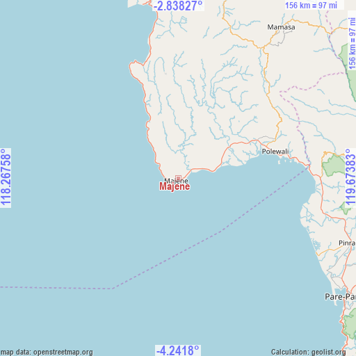
| Upper-left | -2.83827°, | 118.26758° |
| Center: | -3.5403°, | 118.9707° |
| Lower-right: | -4.2418°, | 119.67383° |
| Map W x H: | 156.1×156.1 km | = 97×97mi |
| max Lat: | 5.88969° ⇑9.8% North |
| Majene: | -3.5403° |
| min Lat: | ⇓90.2% South -10.934° |
| min Long | Majene | max Long |
| 95.1345° | 118.9707° | 140.9419° |
| W 80.6%⇐ | ⇒19.4% E |
Elevation
Elevation of Majene is 8 m = 26 ft, and this is 221.7 m = 727 ft below average elevation for this country.
| Max E: |
3185 m = 10449 ft | 93.7% |
| Avg. | 229.7 m = 754 ft | |
| Majene | 8 m = 26 ft | |
Min E: |
-1 m = -3 ft | 6.3% |
See also: Indonesia elevation on elevation.city.
Geographical zone
Majene is located in South Torrid zone (between Equator and Tropic of Capricorn). Distance of Equator is 393.6 km =244.6 mi to North.| Distance of | km | miles | from Majene |
|---|---|---|---|
| Equator | 393.6 | 244.6 | to North |
| Tropic Capricorn | 2212.3 | 1374.7 | to South |
| Antarctic Circle | 7007.5 | 4354.3 | to South |
| South Pole | 9613.4 | 5973.5 | to South |


Nearby cities:
15 places around Majene: (largest is in red/bold)
• Allu
13.1 km =8.1 mi,  10°
10°
• Cempa Pasar
71.9 km =44.7 mi,  108°
108°
• Galunggalung
10.1 km =6.3 mi,  304°
304°
• Lampa
63.9 km =39.7 mi,  102°
102°
• Langnga
70 km =43.5 mi,  119°
119°
• Majennang
85.6 km =53.2 mi, 124°
• Malunda
60 km =37.3 mi,  347°
347°
• Mamasa
80.4 km =50 mi,  34°
34°
• Mambi
69.4 km =43.1 mi,  19°
19°
• Petoosang
12.7 km =7.9 mi, 10°
• Pinrang
80.4 km =50 mi, 109°
• Polewali
43.1 km =26.8 mi,  73°
73°
• Somba
22.7 km =14.1 mi,  322°
322°
• Tapalang
76.1 km =47.3 mi, 351°
• Teppo
79.8 km =49.6 mi, 103°
Sources, notices
• [Note1] Compared only with cities in Indonesia existing in our database
• [Src1] Map data: © OpenStreetMap contributors (CC-BY-SA)
• [Src2] Other city data from geonames.org with taken over terms of usage.
• [Src3] Geographical zone / Annual Mean Temperature by Robert A. Rohde @ Wikipedia
