Plampang geodata
Plampang (West Nusa Tenggara) is a seat of a third-order administrative division; located in Indonesia in Asia/Makassar (GMT+8) time zone. In our database, there are 407 cities with bigger population. Compared to other cities in Indonesia, 91.4% of cities are located further ↑North; 79.3% of cities are located further ←West and 68.9% of cities have higher elevation than Plampang. Note1


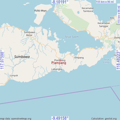
Plampang GPS coordinates[2]
8° 47' 50.64" South, 117° 46' 44.76" East
| Map corner | latitude | longitude |
|---|---|---|
| Upper-left | -8.10191°, | 117.07598° |
| Center: | -8.7974°, | 117.7791° |
| Lower-right: | -9.49158°, | 118.48223° |
| Map W x H: | 154.5×154.5 km | = 96×96mi |
| max Lat: | 5.88969° ⇑91.4% North |
| Plampang: | -8.7974° |
| min Lat: | ⇓8.6% South -10.934° |
| min Long | Plampang | max Long |
| 95.1345° | 117.7791° | 140.9419° |
| W 79.3%⇐ | ⇒20.7% E |
Elevation
Elevation of Plampang is 34 m = 112 ft, and this is 195.7 m = 642 ft below average elevation for this country.
| Max E: |
3185 m = 10449 ft | 68.9% |
| Avg. | 229.7 m = 754 ft | |
| Plampang | 34 m = 112 ft | |
Min E: |
-1 m = -3 ft | 31.1% |
See also: Indonesia elevation on elevation.city.
Geographical zone
Plampang is located in South Torrid zone (between Equator and Tropic of Capricorn). Distance of Equator is 978.2 km =607.8 mi to North.| Distance of | km | miles | from Plampang |
|---|---|---|---|
| Equator | 978.2 | 607.8 | to North |
| Tropic Capricorn | 1627.7 | 1011.4 | to South |
| Antarctic Circle | 6423 | 3991.1 | to South |
| South Pole | 9028.9 | 5610.3 | to South |


Nearby cities:
15 places around Plampang: (largest is in red/bold)
• Ampu
26.2 km =16.3 mi,  71°
71°
• Bantu
28.2 km =17.5 mi,  75°
75°
• Boal Atas
20.2 km =12.6 mi,  88°
88°
• Karangtengah
12.2 km =7.6 mi,  198°
198°
• Labangka Satu
11.5 km =7.1 mi,  185°
185°
• Labuhanjambu
28.8 km =17.9 mi, 67°
• Marisgama
16.5 km =10.3 mi,  219°
219°
• Maronge
16.1 km =10 mi,  330°
330°
• Mekarjaya
10.1 km =6.3 mi,  171°
171°
• Muer
7.6 km =4.7 mi,  315°
315°
• Muhajirin
13.5 km =8.4 mi,  209°
209°
• Parang
23 km =14.3 mi, 75°
• Pisangkemeng
0.6 km =0.4 mi, 198°
• Simu
17.4 km =10.8 mi, 325°
• Teluksantong
14.7 km =9.1 mi,  55°
55°
Sources, notices
• [Note1] Compared only with cities in Indonesia existing in our database
• [Src1] Map data: © OpenStreetMap contributors (CC-BY-SA)
• [Src2] Other city data from geonames.org with taken over terms of usage.
• [Src3] Geographical zone / Annual Mean Temperature by Robert A. Rohde @ Wikipedia
