Labuhanjambu geodata
Labuhanjambu (West Nusa Tenggara) is a seat of a fourth-order administrative division; located in Indonesia in Asia/Makassar (GMT+8) time zone. In our database, there are 407 cities with bigger population. Compared to other cities in Indonesia, 89.2% of cities are located further ↑North; 79.4% of cities are located further ←West and 90.6% of cities have higher elevation than Labuhanjambu. Note1


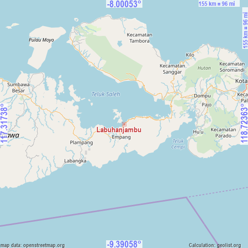
Labuhanjambu GPS coordinates[2]
8° 41' 46.32" South, 118° 1' 13.8" East
| Map corner | latitude | longitude |
|---|---|---|
| Upper-left | -8.00053°, | 117.31738° |
| Center: | -8.6962°, | 118.0205° |
| Lower-right: | -9.39058°, | 118.72363° |
| Map W x H: | 154.6×154.6 km | = 96.1×96.1mi |
| max Lat: | 5.88969° ⇑89.2% North |
| Labuhanjambu: | -8.6962° |
| min Lat: | ⇓10.8% South -10.934° |
| min Long | Labuhanjambu | max Long |
| 95.1345° | 118.0205° | 140.9419° |
| W 79.4%⇐ | ⇒20.6% E |
Elevation
Elevation of Labuhanjambu is 10 m = 33 ft, and this is 219.7 m = 721 ft below average elevation for this country.
| Max E: |
3185 m = 10449 ft | 90.6% |
| Avg. | 229.7 m = 754 ft | |
| Labuhanjambu | 10 m = 33 ft | |
Min E: |
-1 m = -3 ft | 9.4% |
See also: Indonesia elevation on elevation.city.
Geographical zone
Labuhanjambu is located in South Torrid zone (between Equator and Tropic of Capricorn). Distance of Equator is 966.9 km =600.8 mi to North.| Distance of | km | miles | from Labuhanjambu |
|---|---|---|---|
| Equator | 966.9 | 600.8 | to North |
| Tropic Capricorn | 1639 | 1018.4 | to South |
| Antarctic Circle | 6434.2 | 3998 | to South |
| South Pole | 9040.1 | 5617.3 | to South |


Nearby cities:
15 places around Labuhanjambu: (largest is in red/bold)
• Ampu
3.4 km =2.1 mi,  209°
209°
• Bantu
4.2 km =2.6 mi,  170°
170°
• Boal Atas
12.4 km =7.7 mi, 211°
• Kalate
30.2 km =18.8 mi,  55°
55°
• Kempo
30.3 km =18.8 mi, 55°
• Kesi
26.1 km =16.2 mi,  46°
46°
• Konte
28.9 km =18 mi, 54°
• Muer
32.4 km =20.1 mi,  259°
259°
• Ongko
5.4 km =3.4 mi,  152°
152°
• Parang
6.8 km =4.2 mi,  219°
219°
• Pisangkemeng
29.2 km =18.1 mi,  246°
246°
• Plampang
28.8 km =17.9 mi, 247°
• Rasabou
31.3 km =19.4 mi, 55°
• Soro
28.5 km =17.7 mi, 57°
• Teluksantong
14.8 km =9.2 mi, 258°
Sources, notices
• [Note1] Compared only with cities in Indonesia existing in our database
• [Src1] Map data: © OpenStreetMap contributors (CC-BY-SA)
• [Src2] Other city data from geonames.org with taken over terms of usage.
• [Src3] Geographical zone / Annual Mean Temperature by Robert A. Rohde @ Wikipedia
