Pasuruan geodata
Pasuruan (East Java) is a populated place; located in Indonesia in Asia/Jakarta (GMT+7) time zone. With population of 158,600 people, there are 70 cities with bigger population in this country. Compared to other cities in Indonesia, 58.9% of cities are located further ↑North; 58.5% of cities are located further ←West and 92.1% of cities have higher elevation than Pasuruan. Note1


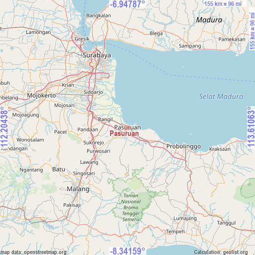
Pasuruan GPS coordinates[2]
7° 38' 43.08" South, 112° 54' 27" East
| Map corner | latitude | longitude |
|---|---|---|
| Upper-left | -6.94787°, | 112.20438° |
| Center: | -7.6453°, | 112.9075° |
| Lower-right: | -8.34159°, | 113.61063° |
| Map W x H: | 155×155 km | = 96.3×96.3mi |
| max Lat: | 5.88969° ⇑58.9% North |
| Pasuruan: | -7.6453° |
| min Lat: | ⇓41.1% South -10.934° |
| min Long | Pasuruan | max Long |
| 95.1345° | 112.9075° | 140.9419° |
| W 58.5%⇐ | ⇒41.5% E |
Elevation
Elevation of Pasuruan is 9 m = 30 ft, and this is 220.7 m = 724 ft below average elevation for this country.
| Max E: |
3185 m = 10449 ft | 92.1% |
| Avg. | 229.7 m = 754 ft | |
| Pasuruan | 9 m = 30 ft | |
Min E: |
-1 m = -3 ft | 7.9% |
See also: Pasuruan elevation on elevation.city.
Geographical zone
Pasuruan is located in South Torrid zone (between Equator and Tropic of Capricorn). Distance of Equator is 850.1 km =528.2 mi to North.| Distance of | km | miles | from Pasuruan |
|---|---|---|---|
| Equator | 850.1 | 528.2 | to North |
| Tropic Capricorn | 1755.8 | 1091 | to South |
| Antarctic Circle | 6551.1 | 4070.7 | to South |
| South Pole | 9157 | 5689.9 | to South |


Nearby cities:
15 places around Pasuruan: (largest is in red/bold)
• Bangil
11 km =6.8 mi,  297°
297°
• Banjarkemuning
30.8 km =19.1 mi,  339°
339°
• Buduran
31.5 km =19.6 mi,  319°
319°
• Buncitan
31 km =19.3 mi,  333°
333°
• Damarsi
30.1 km =18.7 mi, 327°
• Dukuh Tengah
30.6 km =19 mi, 326°
• Dukuhgisikcemandi
30.5 km =19 mi, 338°
• Kalanganyartambak
30.1 km =18.7 mi, 335°
• Kedungpeluk
24.7 km =15.3 mi, 317°
• Lawang
31.6 km =19.6 mi,  227°
227°
• Pandaan
24.3 km =15.1 mi,  268°
268°
• Pepe
31 km =19.3 mi, 330°
• Sawohan
28.6 km =17.8 mi, 328°
• Sidoarjo
30.3 km =18.8 mi, 316°
• Tanggulangin
28 km =17.4 mi,  305°
305°
Sources, notices
• [Note1] Compared only with cities in Indonesia existing in our database
• [Src1] Map data: © OpenStreetMap contributors (CC-BY-SA)
• [Src2] Other city data from geonames.org with taken over terms of usage.
• [Src3] Geographical zone / Annual Mean Temperature by Robert A. Rohde @ Wikipedia
