Serang geodata
Serang (East Java) is a seat of a fourth-order administrative division; located in Indonesia in Asia/Jakarta (GMT+7) time zone. In our database, there are 407 cities with bigger population. Compared to other cities in Indonesia, 77.1% of cities are located further ↑North; 51.8% of cities are located further ←West and 56.1% of cities have higher elevation than Serang. Note1


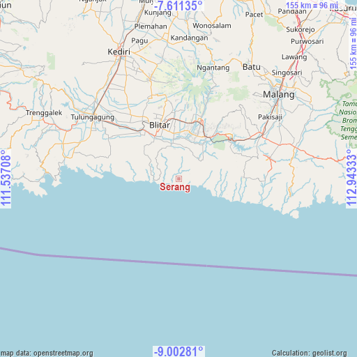
Serang GPS coordinates[2]
8° 18' 27.72" South, 112° 14' 24.72" East
| Map corner | latitude | longitude |
|---|---|---|
| Upper-left | -7.61135°, | 111.53708° |
| Center: | -8.3077°, | 112.2402° |
| Lower-right: | -9.00281°, | 112.94333° |
| Map W x H: | 154.7×154.7 km | = 96.1×96.1mi |
| max Lat: | 5.88969° ⇑77.1% North |
| Serang: | -8.3077° |
| min Lat: | ⇓22.9% South -10.934° |
| min Long | Serang | max Long |
| 95.1345° | 112.2402° | 140.9419° |
| W 51.8%⇐ | ⇒48.2% E |
Elevation
Elevation of Serang is 78 m = 256 ft, and this is 151.7 m = 498 ft below average elevation for this country.
| Max E: |
3185 m = 10449 ft | 56.1% |
| Avg. | 229.7 m = 754 ft | |
| Serang | 78 m = 256 ft | |
Min E: |
-1 m = -3 ft | 43.9% |
See also: Indonesia elevation on elevation.city.
Geographical zone
Serang is located in South Torrid zone (between Equator and Tropic of Capricorn). Distance of Equator is 923.7 km =574 mi to North.| Distance of | km | miles | from Serang |
|---|---|---|---|
| Equator | 923.7 | 574 | to North |
| Tropic Capricorn | 1682.2 | 1045.3 | to South |
| Antarctic Circle | 6477.4 | 4024.9 | to South |
| South Pole | 9083.3 | 5644.1 | to South |


Nearby cities:
15 places around Serang: (largest is in red/bold)
• Balerejo
8.9 km =5.5 mi,  47°
47°
• Becirto
9 km =5.6 mi,  1°
1°
• Gununggede
9.8 km =6.1 mi,  307°
307°
• Kaligambir
5.1 km =3.2 mi, 50°
• Ngadipuro
4.3 km =2.7 mi,  346°
346°
• Ngeni
6.9 km =4.3 mi,  330°
330°
• Panggungrejo
7.6 km =4.7 mi,  33°
33°
• Panggungwinong
9.2 km =5.7 mi, 34°
• Purworejo
10.1 km =6.3 mi,  64°
64°
• Rampalombo
12.4 km =7.7 mi,  12°
12°
• Ringinrejo
12.4 km =7.7 mi,  73°
73°
• Salamrejo
12.3 km =7.6 mi,  41°
41°
• Sumbersih
2.9 km =1.8 mi,  131°
131°
• Tambakrejo
10.7 km =6.6 mi,  267°
267°
• Tulungrejo
10.8 km =6.7 mi, 66°
Sources, notices
• [Note1] Compared only with cities in Indonesia existing in our database
• [Src1] Map data: © OpenStreetMap contributors (CC-BY-SA)
• [Src2] Other city data from geonames.org with taken over terms of usage.
• [Src3] Geographical zone / Annual Mean Temperature by Robert A. Rohde @ Wikipedia
