Ntoke geodata
Ntoke (West Nusa Tenggara) is a seat of a fourth-order administrative division; located in Indonesia in Asia/Makassar (GMT+8) time zone. In our database, there are 407 cities with bigger population. Compared to other cities in Indonesia, 80.6% of cities are located further ↑North; 80.5% of cities are located further ←West and 60.5% of cities have lower elevation than Ntoke. Note1


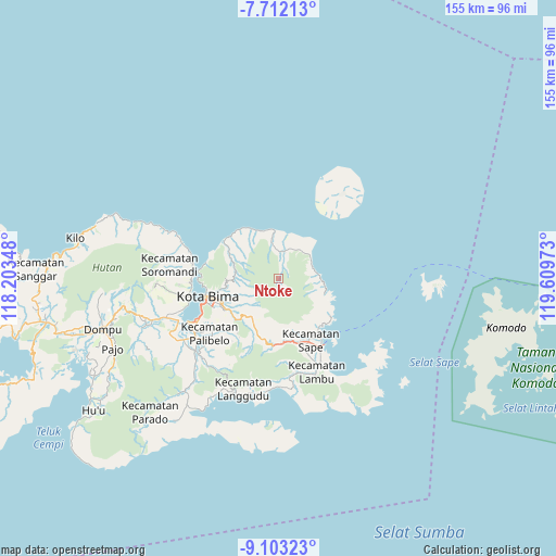
Ntoke GPS coordinates[2]
8° 24' 29.88" South, 118° 54' 23.76" East
| Map corner | latitude | longitude |
|---|---|---|
| Upper-left | -7.71213°, | 118.20348° |
| Center: | -8.4083°, | 118.9066° |
| Lower-right: | -9.10323°, | 119.60973° |
| Map W x H: | 154.7×154.7 km | = 96.1×96.1mi |
| max Lat: | 5.88969° ⇑80.6% North |
| Ntoke: | -8.4083° |
| min Lat: | ⇓19.4% South -10.934° |
| min Long | Ntoke | max Long |
| 95.1345° | 118.9066° | 140.9419° |
| W 80.5%⇐ | ⇒19.5% E |
Elevation
Elevation of Ntoke is 170 m = 558 ft, and this is 59.7 m = 196 ft below average elevation for this country.
| Max E: |
3185 m = 10449 ft | 39.5% |
| Avg. | 229.7 m = 754 ft | |
| Ntoke | 170 m = 558 ft | |
Min E: |
-1 m = -3 ft | 60.5% |
See also: Indonesia elevation on elevation.city.
Geographical zone
Ntoke is located in South Torrid zone (between Equator and Tropic of Capricorn). Distance of Equator is 934.9 km =580.9 mi to North.| Distance of | km | miles | from Ntoke |
|---|---|---|---|
| Equator | 934.9 | 580.9 | to North |
| Tropic Capricorn | 1671 | 1038.3 | to South |
| Antarctic Circle | 6466.3 | 4018 | to South |
| South Pole | 9072.1 | 5637.1 | to South |


Nearby cities:
15 places around Ntoke: (largest is in red/bold)
• Bantawora
9.3 km =5.8 mi,  351°
351°
• Bente
15.1 km =9.4 mi,  295°
295°
• Benteng
5.3 km =3.3 mi,  12°
12°
• Dodu Dua
15.1 km =9.4 mi,  233°
233°
• Hidirasa
9.4 km =5.8 mi, 10°
• Kara
7.7 km =4.8 mi, 9°
• Keli
12 km =7.5 mi,  279°
279°
• Maria
14.6 km =9.1 mi,  208°
208°
• Ntobo
14.7 km =9.1 mi,  251°
251°
• Nungga
15 km =9.3 mi,  236°
236°
• Oitui
11.5 km =7.1 mi,  43°
43°
• Pai
13.3 km =8.3 mi,  101°
101°
• Sangiang
12.7 km =7.9 mi, 13°
• Tawali
7.6 km =4.7 mi, 6°
• Ta’a
14.2 km =8.8 mi, 210°
Sources, notices
• [Note1] Compared only with cities in Indonesia existing in our database
• [Src1] Map data: © OpenStreetMap contributors (CC-BY-SA)
• [Src2] Other city data from geonames.org with taken over terms of usage.
• [Src3] Geographical zone / Annual Mean Temperature by Robert A. Rohde @ Wikipedia
