Nungga geodata
Nungga (West Nusa Tenggara) is a seat of a fourth-order administrative division; located in Indonesia in Asia/Makassar (GMT+8) time zone. In our database, there are 407 cities with bigger population. Compared to other cities in Indonesia, 82.8% of cities are located further ↑North; 80.3% of cities are located further ←West and 56.9% of cities have higher elevation than Nungga. Note1


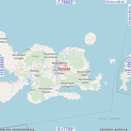
Nungga GPS coordinates[2]
8° 28' 58.44" South, 118° 47' 34.8" East
| Map corner | latitude | longitude |
|---|---|---|
| Upper-left | -7.78685°, | 118.08988° |
| Center: | -8.4829°, | 118.793° |
| Lower-right: | -9.17769°, | 119.49613° |
| Map W x H: | 154.6×154.6 km | = 96.1×96.1mi |
| max Lat: | 5.88969° ⇑82.8% North |
| Nungga: | -8.4829° |
| min Lat: | ⇓17.2% South -10.934° |
| min Long | Nungga | max Long |
| 95.1345° | 118.793° | 140.9419° |
| W 80.3%⇐ | ⇒19.7% E |
Elevation
Elevation of Nungga is 73 m = 240 ft, and this is 156.7 m = 514 ft below average elevation for this country.
| Max E: |
3185 m = 10449 ft | 56.9% |
| Avg. | 229.7 m = 754 ft | |
| Nungga | 73 m = 240 ft | |
Min E: |
-1 m = -3 ft | 43.1% |
See also: Indonesia elevation on elevation.city.
Geographical zone
Nungga is located in South Torrid zone (between Equator and Tropic of Capricorn). Distance of Equator is 943.2 km =586.1 mi to North.| Distance of | km | miles | from Nungga |
|---|---|---|---|
| Equator | 943.2 | 586.1 | to North |
| Tropic Capricorn | 1662.7 | 1033.2 | to South |
| Antarctic Circle | 6458 | 4012.8 | to South |
| South Pole | 9063.9 | 5632 | to South |


Nearby cities:
15 places around Nungga: (largest is in red/bold)
• Dodu Dua
0.8 km =0.5 mi,  153°
153°
• Kendo Satu
2.1 km =1.3 mi,  318°
318°
• Kumbe
2.5 km =1.6 mi,  265°
265°
• Lampe Satu
3.3 km =2.1 mi,  164°
164°
• Lela
6.6 km =4.1 mi, 315°
• Maria
7.1 km =4.4 mi,  129°
129°
• Ntobo
4 km =2.5 mi,  337°
337°
• Ntonggu
6.3 km =3.9 mi,  213°
213°
• Penanae
4.1 km =2.5 mi,  307°
307°
• Penaraga
4.3 km =2.7 mi,  296°
296°
• Pisang
4.2 km =2.6 mi,  290°
290°
• Raba
5.6 km =3.5 mi, 295°
• Rato
3.2 km =2 mi, 287°
• Rontu
4.3 km =2.7 mi, 274°
• Ta’a
6.6 km =4.1 mi, 126°
Sources, notices
• [Note1] Compared only with cities in Indonesia existing in our database
• [Src1] Map data: © OpenStreetMap contributors (CC-BY-SA)
• [Src2] Other city data from geonames.org with taken over terms of usage.
• [Src3] Geographical zone / Annual Mean Temperature by Robert A. Rohde @ Wikipedia
