Nangah Pinoh geodata
Nangah Pinoh (West Kalimantan) is a seat of a second-order administrative division; located in Indonesia in Asia/Pontianak (GMT+7) time zone. In our database, there are 407 cities with bigger population. Compared to other cities in Indonesia, 94.8% of cities are located further ↓South; 53.8% of cities are located further →East and 70.2% of cities have higher elevation than Nangah Pinoh. Note1


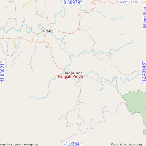
Nangah Pinoh GPS coordinates[2]
0° 19' 59.988" South, 111° 43' 59.988" East
| Map corner | latitude | longitude |
|---|---|---|
| Upper-left | 0.36979°, | 111.03021° |
| Center: | -0.33333°, | 111.73333° |
| Lower-right: | -1.0364°, | 112.43646° |
| Map W x H: | 156.4×156.4 km | = 97.2×97.2mi |
| max Lat: | 5.88969° ⇑5.2% North |
| Nangah Pinoh: | -0.33333° |
| min Lat: | ⇓94.8% South -10.934° |
| min Long | Nangah Pinoh | max Long |
| 95.1345° | 111.73333° | 140.9419° |
| W 46.2%⇐ | ⇒53.8% E |
Elevation
Elevation of Nangah Pinoh is 32 m = 105 ft, and this is 197.7 m = 649 ft below average elevation for this country.
| Max E: |
3185 m = 10449 ft | 70.2% |
| Avg. | 229.7 m = 754 ft | |
| Nangah Pinoh | 32 m = 105 ft | |
Min E: |
-1 m = -3 ft | 29.8% |
See also: Indonesia elevation on elevation.city.
Geographical zone
Nangah Pinoh is located in South Torrid zone (between Equator and Tropic of Capricorn). Distance of Equator is 37.1 km =23.1 mi to North.| Distance of | km | miles | from Nangah Pinoh |
|---|---|---|---|
| Equator | 37.1 | 23.1 | to North |
| Tropic Capricorn | 2568.9 | 1596.2 | to South |
| Antarctic Circle | 7364.1 | 4575.8 | to South |
| South Pole | 9970 | 6195.1 | to South |


Nearby cities:
15 places around Nangah Pinoh: (largest is in red/bold)
• Balaiberkuak
153.5 km =95.4 mi,  261°
261°
• Kenyau
150.3 km =93.4 mi,  245°
245°
• Kotawaringin
239.6 km =148.9 mi,  186°
186°
• Meliau
162.2 km =100.8 mi,  278°
278°
• Nanga Bulik
205.2 km =127.5 mi, 187°
• Ngabang
213.7 km =132.8 mi,  291°
291°
• Putussibau
186.1 km =115.6 mi,  45°
45°
• Rantaupulut
193.3 km =120.1 mi,  164°
164°
• Sanggau
136.3 km =84.7 mi, 292°
• Sekadau
100.5 km =62.4 mi, 292°
• Semilat
225.9 km =140.4 mi,  166°
166°
• Sintang
51.5 km =32 mi,  329°
329°
• Sukadana
222.9 km =138.5 mi,  242°
242°
• Tayan
184.4 km =114.6 mi, 280°
• Terentang
234.9 km =146 mi,  268°
268°
Sources, notices
• [Note1] Compared only with cities in Indonesia existing in our database
• [Src1] Map data: © OpenStreetMap contributors (CC-BY-SA)
• [Src2] Other city data from geonames.org with taken over terms of usage.
• [Src3] Geographical zone / Annual Mean Temperature by Robert A. Rohde @ Wikipedia
