Nanga Bulik geodata
Nanga Bulik (Central Kalimantan) is a seat of a second-order administrative division; located in Indonesia in Asia/Pontianak (GMT+7) time zone. In our database, there are 407 cities with bigger population. Compared to other cities in Indonesia, 92.7% of cities are located further ↓South; 58.1% of cities are located further →East and 78.1% of cities have higher elevation than Nanga Bulik. Note1


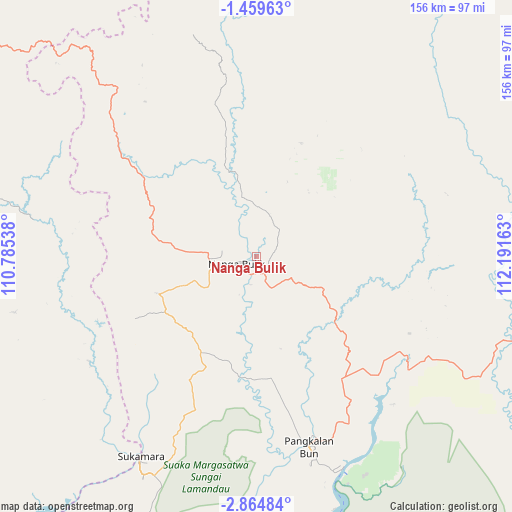
Nanga Bulik GPS coordinates[2]
2° 9' 44.64" South, 111° 29' 18.6" East
| Map corner | latitude | longitude |
|---|---|---|
| Upper-left | -1.45963°, | 110.78538° |
| Center: | -2.1624°, | 111.4885° |
| Lower-right: | -2.86484°, | 112.19163° |
| Map W x H: | 156.2×156.2 km | = 97.1×97.1mi |
| max Lat: | 5.88969° ⇑7.3% North |
| Nanga Bulik: | -2.1624° |
| min Lat: | ⇓92.7% South -10.934° |
| min Long | Nanga Bulik | max Long |
| 95.1345° | 111.4885° | 140.9419° |
| W 41.9%⇐ | ⇒58.1% E |
Elevation
Elevation of Nanga Bulik is 21 m = 69 ft, and this is 208.7 m = 685 ft below average elevation for this country.
| Max E: |
3185 m = 10449 ft | 78.1% |
| Avg. | 229.7 m = 754 ft | |
| Nanga Bulik | 21 m = 69 ft | |
Min E: |
-1 m = -3 ft | 21.9% |
See also: Indonesia elevation on elevation.city.
Geographical zone
Nanga Bulik is located in South Torrid zone (between Equator and Tropic of Capricorn). Distance of Equator is 240.4 km =149.4 mi to North.| Distance of | km | miles | from Nanga Bulik |
|---|---|---|---|
| Equator | 240.4 | 149.4 | to North |
| Tropic Capricorn | 2365.5 | 1469.9 | to South |
| Antarctic Circle | 7160.7 | 4449.5 | to South |
| South Pole | 9766.6 | 6068.7 | to South |


Nearby cities:
15 places around Nanga Bulik: (largest is in red/bold)
• Halimaung Jaya (F-3)
168.4 km =104.6 mi,  135°
135°
• Kenyau
178.4 km =110.9 mi,  322°
322°
• Ketapang
171.7 km =106.7 mi,  282°
282°
• Kotabesi
169.8 km =105.5 mi,  97°
97°
• Kotawaringin
34.6 km =21.5 mi,  182°
182°
• Kuala Pembuang
180.6 km =112.2 mi, 139°
• Kumai
69.4 km =43.1 mi,  157°
157°
• Manismata
60.8 km =37.8 mi,  236°
236°
• Pangkalanbuun
59.9 km =37.2 mi,  165°
165°
• Pembuanghulu
83.2 km =51.7 mi,  117°
117°
• Rantaupulut
80.4 km =50 mi,  77°
77°
• Sampit
167.4 km =104 mi, 104°
• Semilat
82 km =51 mi, 101°
• Semuda
182.3 km =113.3 mi, 115°
• Sukadana
198.8 km =123.5 mi,  300°
300°
Sources, notices
• [Note1] Compared only with cities in Indonesia existing in our database
• [Src1] Map data: © OpenStreetMap contributors (CC-BY-SA)
• [Src2] Other city data from geonames.org with taken over terms of usage.
• [Src3] Geographical zone / Annual Mean Temperature by Robert A. Rohde @ Wikipedia
