Singkawang geodata
Singkawang (West Kalimantan) is a populated place; located in Indonesia in Asia/Pontianak (GMT+7) time zone. With population of 101,838 people, there are 128 cities with bigger population in this country. Compared to other cities in Indonesia, 96.1% of cities are located further ↓South; 67% of cities are located further →East and 99.7% of cities have higher elevation than Singkawang. Note1


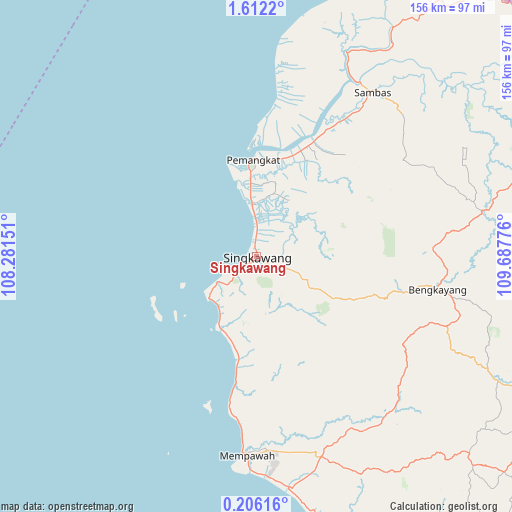
Singkawang GPS coordinates[2]
0° 54' 33.3" North, 108° 59' 4.668" East
| Map corner | latitude | longitude |
|---|---|---|
| Upper-left | 1.6122°, | 108.28151° |
| Center: | 0.90925°, | 108.98463° |
| Lower-right: | 0.20616°, | 109.68776° |
| Map W x H: | 156.3×156.3 km | = 97.1×97.1mi |
| max Lat: | 5.88969° ⇑3.9% North |
| Singkawang: | 0.90925° |
| min Lat: | ⇓96.1% South -10.934° |
| min Long | Singkawang | max Long |
| 95.1345° | 108.98463° | 140.9419° |
| W 33%⇐ | ⇒67% E |
Elevation
Elevation of Singkawang is 2 m = 7 ft, and this is 227.7 m = 747 ft below average elevation for this country.
| Max E: |
3185 m = 10449 ft | 99.7% |
| Avg. | 229.7 m = 754 ft | |
| Singkawang | 2 m = 7 ft | |
Min E: |
-1 m = -3 ft | 0.3% |
See also: Singkawang elevation on elevation.city.
Geographical zone
Singkawang is located in North Torrid zone (between Equator and Tropic of Cancer). Distance of Equator is 101.1 km =62.8 mi to South.| Distance of | km | miles | from Singkawang |
|---|---|---|---|
| North Pole | 9906 | 6155.3 | to North |
| Arctic Circle | 7300.1 | 4536.1 | to North |
| Tropic Cancer | 2504.8 | 1556.4 | to North |
| Equator | 101.1 | 62.8 | to South |


Nearby cities:
15 places around Singkawang: (largest is in red/bold)
• Bengkayang
50.9 km =31.6 mi,  99°
99°
• Karangan
58.3 km =36.2 mi,  131°
131°
• Mandor
76.2 km =47.3 mi,  148°
148°
• Mempawah
59.9 km =37.2 mi,  181°
181°
• Menjalin
62.8 km =39 mi,  141°
141°
• Pemangkat
28.7 km =17.8 mi,  356°
356°
• Pontianak
111.3 km =69.2 mi,  160°
160°
• Pontianak Barat
109.7 km =68.2 mi, 160°
• Samalantan
26.9 km =16.7 mi,  118°
118°
• Sambas
55.6 km =34.5 mi,  32°
32°
• Sungai Pinyuh
70.4 km =43.7 mi,  171°
171°
• Sungai Raya
25.1 km =15.6 mi,  202°
202°
• Sungaiduri
38.6 km =24 mi,  189°
189°
• Sungaikakap
109.7 km =68.2 mi, 166°
• Toho
60.6 km =37.7 mi, 154°
Sources, notices
• [Note1] Compared only with cities in Indonesia existing in our database
• [Src1] Map data: © OpenStreetMap contributors (CC-BY-SA)
• [Src2] Other city data from geonames.org with taken over terms of usage.
• [Src3] Geographical zone / Annual Mean Temperature by Robert A. Rohde @ Wikipedia
