Mega geodata
Mega (West Papua) is a seat of a third-order administrative division; located in Indonesia in Asia/Jayapura (GMT+9) time zone. In our database, there are 407 cities with bigger population. Compared to other cities in Indonesia, 94.3% of cities are located further ↓South; 98.8% of cities are located further ←West and 92.1% of cities have higher elevation than Mega. Note1


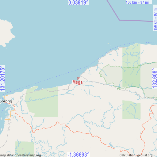
Mega GPS coordinates[2]
0° 39' 50.112" South, 131° 54' 17.532" East
| Map corner | latitude | longitude |
|---|---|---|
| Upper-left | 0.03919°, | 131.20175° |
| Center: | -0.66392°, | 131.90487° |
| Lower-right: | -1.36693°, | 132.608° |
| Map W x H: | 156.3×156.3 km | = 97.1×97.1mi |
| max Lat: | 5.88969° ⇑5.7% North |
| Mega: | -0.66392° |
| min Lat: | ⇓94.3% South -10.934° |
| min Long | Mega | max Long |
| 95.1345° | 131.90487° | 140.9419° |
| W 98.8%⇐ | ⇒1.2% E |
Elevation
Elevation of Mega is 9 m = 30 ft, and this is 220.7 m = 724 ft below average elevation for this country.
| Max E: |
3185 m = 10449 ft | 92.1% |
| Avg. | 229.7 m = 754 ft | |
| Mega | 9 m = 30 ft | |
Min E: |
-1 m = -3 ft | 7.9% |
See also: Indonesia elevation on elevation.city.
Geographical zone
Mega is located in South Torrid zone (between Equator and Tropic of Capricorn). Distance of Equator is 73.8 km =45.9 mi to North.| Distance of | km | miles | from Mega |
|---|---|---|---|
| Equator | 73.8 | 45.9 | to North |
| Tropic Capricorn | 2532.1 | 1573.4 | to South |
| Antarctic Circle | 7327.4 | 4553 | to South |
| South Pole | 9933.2 | 6172.2 | to South |


Nearby cities:
15 places around Mega: (largest is in red/bold)
• Aifat
86.7 km =53.9 mi,  130°
130°
• Aimas
71.2 km =44.2 mi,  242°
242°
• Aitinyo
87.1 km =54.1 mi,  145°
145°
• Ayamaru
75.1 km =46.7 mi, 154°
• Doom
78.4 km =48.7 mi,  251°
251°
• Fef
60.8 km =37.8 mi,  105°
105°
• Kumurkek
93.4 km =58 mi, 134°
• Makbon
41.8 km =26 mi,  257°
257°
• Saonek
130.2 km =80.9 mi,  281°
281°
• Saukorem
139.2 km =86.5 mi,  85°
85°
• Sausapor
27.2 km =16.9 mi,  47°
47°
• Seget
132.7 km =82.5 mi,  231°
231°
• Sorong
75.5 km =46.9 mi, 251°
• Teminabuan
87.3 km =54.2 mi,  171°
171°
• Wanurian
74.9 km =46.5 mi,  210°
210°
Sources, notices
• [Note1] Compared only with cities in Indonesia existing in our database
• [Src1] Map data: © OpenStreetMap contributors (CC-BY-SA)
• [Src2] Other city data from geonames.org with taken over terms of usage.
• [Src3] Geographical zone / Annual Mean Temperature by Robert A. Rohde @ Wikipedia
