Wanurian geodata
Wanurian (West Papua) is a seat of a third-order administrative division; located in Indonesia in Asia/Jayapura (GMT+9) time zone. In our database, there are 407 cities with bigger population. Compared to other cities in Indonesia, 93.7% of cities are located further ↓South; 98.8% of cities are located further ←West and 84.2% of cities have higher elevation than Wanurian. Note1


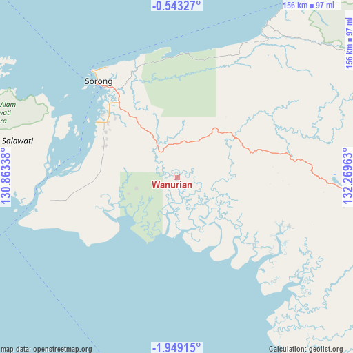
Wanurian GPS coordinates[2]
1° 14' 46.68" South, 131° 33' 59.4" East
| Map corner | latitude | longitude |
|---|---|---|
| Upper-left | -0.54327°, | 130.86338° |
| Center: | -1.2463°, | 131.5665° |
| Lower-right: | -1.94915°, | 132.26963° |
| Map W x H: | 156.3×156.3 km | = 97.1×97.1mi |
| max Lat: | 5.88969° ⇑6.3% North |
| Wanurian: | -1.2463° |
| min Lat: | ⇓93.7% South -10.934° |
| min Long | Wanurian | max Long |
| 95.1345° | 131.5665° | 140.9419° |
| W 98.8%⇐ | ⇒1.2% E |
Elevation
Elevation of Wanurian is 15 m = 49 ft, and this is 214.7 m = 704 ft below average elevation for this country.
| Max E: |
3185 m = 10449 ft | 84.2% |
| Avg. | 229.7 m = 754 ft | |
| Wanurian | 15 m = 49 ft | |
Min E: |
-1 m = -3 ft | 15.8% |
See also: Indonesia elevation on elevation.city.
Geographical zone
Wanurian is located in South Torrid zone (between Equator and Tropic of Capricorn). Distance of Equator is 138.6 km =86.1 mi to North.| Distance of | km | miles | from Wanurian |
|---|---|---|---|
| Equator | 138.6 | 86.1 | to North |
| Tropic Capricorn | 2467.3 | 1533.1 | to South |
| Antarctic Circle | 7262.6 | 4512.8 | to South |
| South Pole | 9868.5 | 6132 | to South |


Nearby cities:
15 places around Wanurian: (largest is in red/bold)
• Aifat
104.3 km =64.8 mi,  85°
85°
• Aimas
41.2 km =25.6 mi,  321°
321°
• Aitinyo
86.8 km =53.9 mi, 94°
• Ayamaru
69.8 km =43.4 mi, 92°
• Doom
54.2 km =33.7 mi, 317°
• Fef
107.8 km =67 mi,  63°
63°
• Kumurkek
103.7 km =64.4 mi, 90°
• Makbon
55.5 km =34.5 mi,  356°
356°
• Mega
74.9 km =46.5 mi,  30°
30°
• Saonek
127.3 km =79.1 mi,  314°
314°
• Sausapor
101.1 km =62.8 mi, 34°
• Seget
68.3 km =42.4 mi,  254°
254°
• Serkos
118.4 km =73.6 mi,  145°
145°
• Sorong
53.1 km =33 mi, 320°
• Teminabuan
54.3 km =33.7 mi,  113°
113°
Sources, notices
• [Note1] Compared only with cities in Indonesia existing in our database
• [Src1] Map data: © OpenStreetMap contributors (CC-BY-SA)
• [Src2] Other city data from geonames.org with taken over terms of usage.
• [Src3] Geographical zone / Annual Mean Temperature by Robert A. Rohde @ Wikipedia
