Aimas geodata
Aimas (West Papua) is a seat of a second-order administrative division; located in Indonesia in Asia/Jayapura (GMT+9) time zone. In our database, there are 407 cities with bigger population. Compared to other cities in Indonesia, 93.9% of cities are located further ↓South; 98.8% of cities are located further ←West and 92.1% of cities have higher elevation than Aimas. Note1


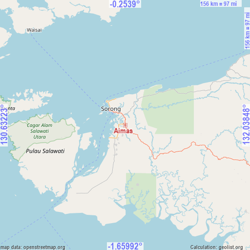
Aimas GPS coordinates[2]
0° 57' 25.128" South, 131° 20' 7.26" East
| Map corner | latitude | longitude |
|---|---|---|
| Upper-left | -0.2539°, | 130.63223° |
| Center: | -0.95698°, | 131.33535° |
| Lower-right: | -1.65992°, | 132.03848° |
| Map W x H: | 156.3×156.3 km | = 97.1×97.1mi |
| max Lat: | 5.88969° ⇑6.1% North |
| Aimas: | -0.95698° |
| min Lat: | ⇓93.9% South -10.934° |
| min Long | Aimas | max Long |
| 95.1345° | 131.33535° | 140.9419° |
| W 98.8%⇐ | ⇒1.2% E |
Elevation
Elevation of Aimas is 9 m = 30 ft, and this is 220.7 m = 724 ft below average elevation for this country.
| Max E: |
3185 m = 10449 ft | 92.1% |
| Avg. | 229.7 m = 754 ft | |
| Aimas | 9 m = 30 ft | |
Min E: |
-1 m = -3 ft | 7.9% |
See also: Indonesia elevation on elevation.city.
Geographical zone
Aimas is located in South Torrid zone (between Equator and Tropic of Capricorn). Distance of Equator is 106.4 km =66.1 mi to North.| Distance of | km | miles | from Aimas |
|---|---|---|---|
| Equator | 106.4 | 66.1 | to North |
| Tropic Capricorn | 2499.5 | 1553.1 | to South |
| Antarctic Circle | 7294.8 | 4532.8 | to South |
| South Pole | 9900.7 | 6152 | to South |


Nearby cities:
15 places around Aimas: (largest is in red/bold)
• Aifat
131.7 km =81.8 mi,  100°
100°
• Aitinyo
118.9 km =73.9 mi,  109°
109°
• Ayamaru
101.7 km =63.2 mi, 110°
• Doom
13.5 km =8.4 mi,  305°
305°
• Fef
123.1 km =76.5 mi,  82°
82°
• Kabare
118.8 km =73.8 mi,  331°
331°
• Makbon
32.5 km =20.2 mi,  44°
44°
• Mega
71.2 km =44.2 mi,  62°
62°
• Saonek
86.5 km =53.7 mi, 311°
• Sausapor
97.7 km =60.7 mi, 58°
• Seget
64.5 km =40.1 mi,  218°
218°
• Sorong
11.9 km =7.4 mi,  316°
316°
• Teminabuan
92.7 km =57.6 mi,  125°
125°
• Waisai
121.9 km =75.7 mi, 310°
• Wanurian
41.2 km =25.6 mi,  141°
141°
Sources, notices
• [Note1] Compared only with cities in Indonesia existing in our database
• [Src1] Map data: © OpenStreetMap contributors (CC-BY-SA)
• [Src2] Other city data from geonames.org with taken over terms of usage.
• [Src3] Geographical zone / Annual Mean Temperature by Robert A. Rohde @ Wikipedia
