Fef geodata
Fef (West Papua) is a seat of a second-order administrative division; located in Indonesia in Asia/Jayapura (GMT+9) time zone. In our database, there are 407 cities with bigger population. Compared to other cities in Indonesia, 94.1% of cities are located further ↓South; 98.9% of cities are located further ←West and 79.6% of cities have lower elevation than Fef. Note1


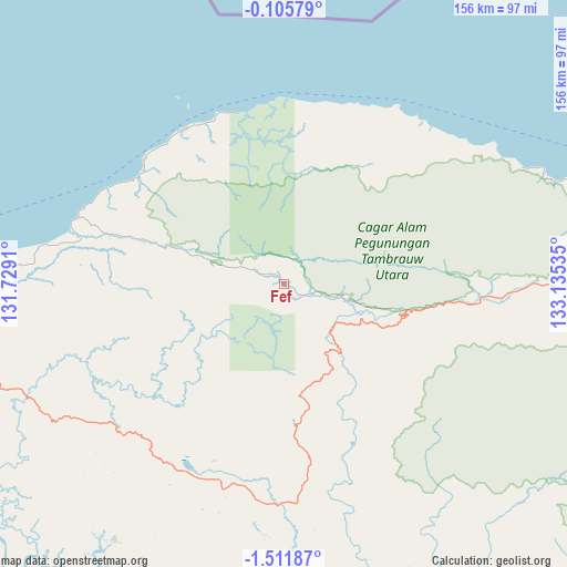
Fef GPS coordinates[2]
0° 48' 32.004" South, 132° 25' 55.992" East
| Map corner | latitude | longitude |
|---|---|---|
| Upper-left | -0.10579°, | 131.7291° |
| Center: | -0.80889°, | 132.43222° |
| Lower-right: | -1.51187°, | 133.13535° |
| Map W x H: | 156.3×156.3 km | = 97.1×97.1mi |
| max Lat: | 5.88969° ⇑5.9% North |
| Fef: | -0.80889° |
| min Lat: | ⇓94.1% South -10.934° |
| min Long | Fef | max Long |
| 95.1345° | 132.43222° | 140.9419° |
| W 98.9%⇐ | ⇒1.1% E |
Elevation
Elevation of Fef is 426 m = 1398 ft, and this is 196.3 m = 644 ft above average elevation for this country.
| Max E: |
3185 m = 10449 ft | 20.4% |
| Fef | 426 m 1398 ft | |
| Avg. | 229.7 m = 754 ft | |
Min E: |
-1 m = -3 ft | 79.6% |
See also: Indonesia elevation on elevation.city.
Geographical zone
Fef is located in South Torrid zone (between Equator and Tropic of Capricorn). Distance of Equator is 89.9 km =55.9 mi to North.| Distance of | km | miles | from Fef |
|---|---|---|---|
| Equator | 89.9 | 55.9 | to North |
| Tropic Capricorn | 2516 | 1563.4 | to South |
| Antarctic Circle | 7311.2 | 4543 | to South |
| South Pole | 9917.1 | 6162.2 | to South |


Nearby cities:
15 places around Fef: (largest is in red/bold)
• Aifat
40.5 km =25.2 mi,  169°
169°
• Aimas
123.1 km =76.5 mi,  262°
262°
• Aitinyo
56.8 km =35.3 mi,  189°
189°
• Ayamaru
58.2 km =36.2 mi,  207°
207°
• Doom
133.2 km =82.8 mi,  266°
266°
• Kebar
79.4 km =49.3 mi,  93°
93°
• Kumurkek
50.4 km =31.3 mi, 171°
• Makbon
99.6 km =61.9 mi, 273°
• Mega
60.8 km =37.8 mi,  285°
285°
• Merdey
139.2 km =86.5 mi,  132°
132°
• Saukorem
84.6 km =52.6 mi,  71°
71°
• Sausapor
51.6 km =32.1 mi,  311°
311°
• Sorong
130.4 km =81 mi, 266°
• Teminabuan
84.3 km =52.4 mi, 213°
• Wanurian
107.8 km =67 mi,  243°
243°
Sources, notices
• [Note1] Compared only with cities in Indonesia existing in our database
• [Src1] Map data: © OpenStreetMap contributors (CC-BY-SA)
• [Src2] Other city data from geonames.org with taken over terms of usage.
• [Src3] Geographical zone / Annual Mean Temperature by Robert A. Rohde @ Wikipedia
