Sekernan geodata
Sekernan (Jambi) is a seat of a third-order administrative division; located in Indonesia in Asia/Jakarta (GMT+7) time zone. In our database, there are 407 cities with bigger population. Compared to other cities in Indonesia, 93.4% of cities are located further ↓South; 95.4% of cities are located further →East and 80.9% of cities have higher elevation than Sekernan. Note1


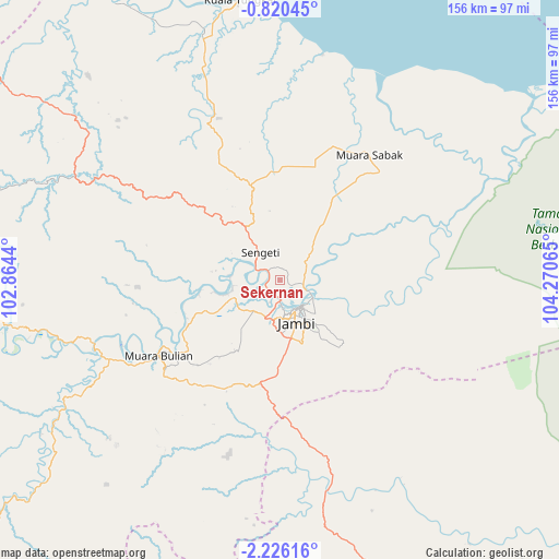
Sekernan GPS coordinates[2]
1° 31' 24.312" South, 103° 34' 3.072" East
| Map corner | latitude | longitude |
|---|---|---|
| Upper-left | -0.82045°, | 102.8644° |
| Center: | -1.52342°, | 103.56752° |
| Lower-right: | -2.22616°, | 104.27065° |
| Map W x H: | 156.3×156.3 km | = 97.1×97.1mi |
| max Lat: | 5.88969° ⇑6.6% North |
| Sekernan: | -1.52342° |
| min Lat: | ⇓93.4% South -10.934° |
| min Long | Sekernan | max Long |
| 95.1345° | 103.56752° | 140.9419° |
| W 4.6%⇐ | ⇒95.4% E |
Elevation
Elevation of Sekernan is 18 m = 59 ft, and this is 211.7 m = 695 ft below average elevation for this country.
| Max E: |
3185 m = 10449 ft | 80.9% |
| Avg. | 229.7 m = 754 ft | |
| Sekernan | 18 m = 59 ft | |
Min E: |
-1 m = -3 ft | 19.1% |
See also: Indonesia elevation on elevation.city.
Geographical zone
Sekernan is located in South Torrid zone (between Equator and Tropic of Capricorn). Distance of Equator is 169.4 km =105.3 mi to North.| Distance of | km | miles | from Sekernan |
|---|---|---|---|
| Equator | 169.4 | 105.3 | to North |
| Tropic Capricorn | 2436.5 | 1514 | to South |
| Antarctic Circle | 7231.8 | 4493.6 | to South |
| South Pole | 9837.7 | 6112.9 | to South |


Nearby cities:
15 places around Sekernan: (largest is in red/bold)
• Bayunglincir
60.5 km =37.6 mi,  167°
167°
• Bejubang Dua
40.9 km =25.4 mi,  222°
222°
• Jambi City
10.1 km =6.3 mi,  147°
147°
• Kenali Asam
16.8 km =10.4 mi,  159°
159°
• Kuala Tungkal
79.5 km =49.4 mi,  351°
351°
• Mendaha
56.5 km =35.1 mi,  2°
2°
• Mersam
66.3 km =41.2 mi,  252°
252°
• Muara Bulian
40.3 km =25 mi,  238°
238°
• Muara Sabak
53.3 km =33.1 mi,  36°
36°
• Muara Tembesi
54.1 km =33.6 mi, 247°
• Nipah Panjang
85.7 km =53.3 mi,  54°
54°
• Pelabuhan Dagang
68.1 km =42.3 mi,  308°
308°
• Sengeti
8.4 km =5.2 mi, 307°
• Simpang
65.5 km =40.7 mi,  63°
63°
• Sungaibengkal
94.1 km =58.5 mi,  269°
269°
Sources, notices
• [Note1] Compared only with cities in Indonesia existing in our database
• [Src1] Map data: © OpenStreetMap contributors (CC-BY-SA)
• [Src2] Other city data from geonames.org with taken over terms of usage.
• [Src3] Geographical zone / Annual Mean Temperature by Robert A. Rohde @ Wikipedia
