Lubukgadang geodata
Lubukgadang (West Sumatra) is a seat of a third-order administrative division; located in Indonesia in Asia/Jakarta (GMT+7) time zone. In our database, there are 407 cities with bigger population. Compared to other cities in Indonesia, 93.4% of cities are located further ↓South; 96.5% of cities are located further →East and 79.7% of cities have lower elevation than Lubukgadang. Note1


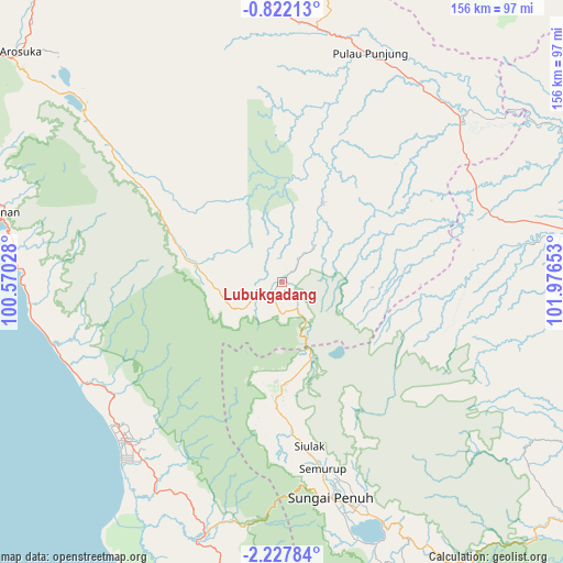
Lubukgadang GPS coordinates[2]
1° 31' 30.36" South, 101° 16' 24.24" East
| Map corner | latitude | longitude |
|---|---|---|
| Upper-left | -0.82213°, | 100.57028° |
| Center: | -1.5251°, | 101.2734° |
| Lower-right: | -2.22784°, | 101.97653° |
| Map W x H: | 156.3×156.3 km | = 97.1×97.1mi |
| max Lat: | 5.88969° ⇑6.6% North |
| Lubukgadang: | -1.5251° |
| min Lat: | ⇓93.4% South -10.934° |
| min Long | Lubukgadang | max Long |
| 95.1345° | 101.2734° | 140.9419° |
| W 3.5%⇐ | ⇒96.5% E |
Elevation
Elevation of Lubukgadang is 428 m = 1404 ft, and this is 198.3 m = 651 ft above average elevation for this country.
| Max E: |
3185 m = 10449 ft | 20.3% |
| Lubukgadang | 428 m 1404 ft | |
| Avg. | 229.7 m = 754 ft | |
Min E: |
-1 m = -3 ft | 79.7% |
See also: Indonesia elevation on elevation.city.
Geographical zone
Lubukgadang is located in South Torrid zone (between Equator and Tropic of Capricorn). Distance of Equator is 169.6 km =105.4 mi to North.| Distance of | km | miles | from Lubukgadang |
|---|---|---|---|
| Equator | 169.6 | 105.4 | to North |
| Tropic Capricorn | 2436.3 | 1513.8 | to South |
| Antarctic Circle | 7231.6 | 4493.5 | to South |
| South Pole | 9837.5 | 6112.7 | to South |


Nearby cities:
15 places around Lubukgadang: (largest is in red/bold)
• Alahanpanjang
73.2 km =45.5 mi,  313°
313°
• Kambang
64.1 km =39.8 mi,  253°
253°
• Kotabaru
71.7 km =44.6 mi,  48°
48°
• Mandarahan
57.8 km =35.9 mi,  238°
238°
• Muaralabuh
28.7 km =17.8 mi,  284°
284°
• Padang Aro
1.1 km =0.7 mi,  257°
257°
• Painan
80.1 km =49.8 mi, 283°
• Pasarkuok
73 km =45.4 mi, 277°
• Pulau Punjung
67.8 km =42.1 mi,  21°
21°
• Rantauambacang
73.3 km =45.5 mi,  78°
78°
• Semurup
53 km =32.9 mi,  168°
168°
• Siulak
47.4 km =29.5 mi, 171°
• Siulakderasmudik
42.7 km =26.5 mi,  186°
186°
• Sungai Penuh
60.5 km =37.6 mi, 167°
• Surian
52.9 km =32.9 mi,  304°
304°
Sources, notices
• [Note1] Compared only with cities in Indonesia existing in our database
• [Src1] Map data: © OpenStreetMap contributors (CC-BY-SA)
• [Src2] Other city data from geonames.org with taken over terms of usage.
• [Src3] Geographical zone / Annual Mean Temperature by Robert A. Rohde @ Wikipedia
