Sungai Penuh geodata
Sungai Penuh (Jambi) is a populated place; located in Indonesia in Asia/Jakarta (GMT+7) time zone. With population of 95,913 people, there are 137 cities with bigger population in this country. Compared to other cities in Indonesia, 92.9% of cities are located further ↓South; 96.4% of cities are located further →East and 94.9% of cities have lower elevation than Sungai Penuh. Note1


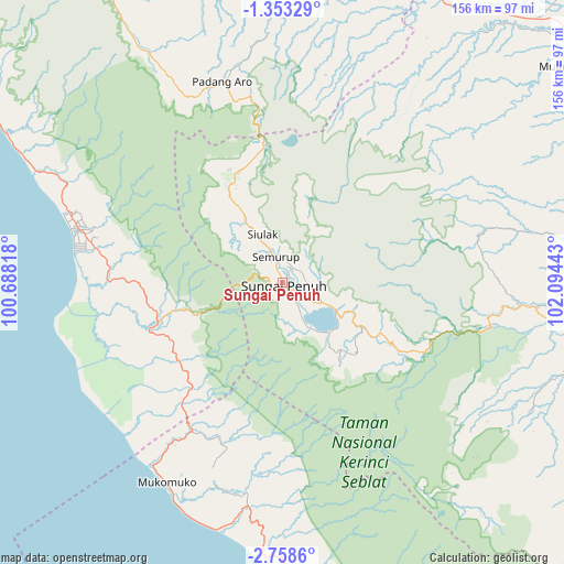
Sungai Penuh GPS coordinates[2]
2° 3' 21.96" South, 101° 23' 28.68" East
| Map corner | latitude | longitude |
|---|---|---|
| Upper-left | -1.35329°, | 100.68818° |
| Center: | -2.0561°, | 101.3913° |
| Lower-right: | -2.7586°, | 102.09443° |
| Map W x H: | 156.3×156.3 km | = 97.1×97.1mi |
| max Lat: | 5.88969° ⇑7.1% North |
| Sungai Penuh: | -2.0561° |
| min Lat: | ⇓92.9% South -10.934° |
| min Long | Sungai Penuh | max Long |
| 95.1345° | 101.3913° | 140.9419° |
| W 3.6%⇐ | ⇒96.4% E |
Elevation
Elevation of Sungai Penuh is 811 m = 2661 ft, and this is 581.3 m = 1907 ft above average elevation for this country.
| Max E: |
3185 m = 10449 ft | 5.1% |
| Sungai Penuh | 811 m 2661 ft | |
| Avg. | 229.7 m = 754 ft | |
Min E: |
-1 m = -3 ft | 94.9% |
See also: Sungai Penuh elevation on elevation.city.
Geographical zone
Sungai Penuh is located in South Torrid zone (between Equator and Tropic of Capricorn). Distance of Equator is 228.6 km =142 mi to North.| Distance of | km | miles | from Sungai Penuh |
|---|---|---|---|
| Equator | 228.6 | 142 | to North |
| Tropic Capricorn | 2377.3 | 1477.2 | to South |
| Antarctic Circle | 7172.6 | 4456.8 | to South |
| South Pole | 9778.4 | 6076 | to South |


Nearby cities:
15 places around Sungai Penuh: (largest is in red/bold)
• Bangko
96.3 km =59.8 mi,  91°
91°
• Jangkat
89.1 km =55.4 mi,  124°
124°
• Kambang
84.9 km =52.8 mi,  298°
298°
• Lubukgadang
60.5 km =37.6 mi,  347°
347°
• Mandarahan
68.8 km =42.8 mi,  294°
294°
• Muara Bungo
102.1 km =63.4 mi,  51°
51°
• Muaralabuh
77.7 km =48.3 mi,  328°
328°
• Muarasiau
82.3 km =51.1 mi,  107°
107°
• Mukomuko
64.9 km =40.3 mi,  208°
208°
• Padang Aro
60.5 km =37.6 mi, 346°
• Rantauambacang
93.9 km =58.3 mi,  38°
38°
• Rantaupanjang
104.6 km =65 mi,  77°
77°
• Semurup
7.6 km =4.7 mi,  340°
340°
• Siulak
13.7 km =8.5 mi, 332°
• Siulakderasmudik
24.4 km =15.2 mi,  312°
312°
Sources, notices
• [Note1] Compared only with cities in Indonesia existing in our database
• [Src1] Map data: © OpenStreetMap contributors (CC-BY-SA)
• [Src2] Other city data from geonames.org with taken over terms of usage.
• [Src3] Geographical zone / Annual Mean Temperature by Robert A. Rohde @ Wikipedia
