Lembar geodata
Lembar (West Nusa Tenggara) is a populated place; located in Indonesia in Asia/Makassar (GMT+8) time zone. With population of 10,000 people, there are 376 cities with bigger population in this country. Compared to other cities in Indonesia, 89.9% of cities are located further ↑North; 75.9% of cities are located further ←West and 95.5% of cities have higher elevation than Lembar. Note1


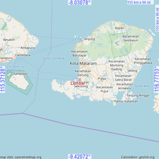
Lembar GPS coordinates[2]
8° 43' 35.04" South, 116° 4' 27.84" East
| Map corner | latitude | longitude |
|---|---|---|
| Upper-left | -8.03078°, | 115.37128° |
| Center: | -8.7264°, | 116.0744° |
| Lower-right: | -9.42072°, | 116.77753° |
| Map W x H: | 154.5×154.6 km | = 96×96.1mi |
| max Lat: | 5.88969° ⇑89.9% North |
| Lembar: | -8.7264° |
| min Lat: | ⇓10.1% South -10.934° |
| min Long | Lembar | max Long |
| 95.1345° | 116.0744° | 140.9419° |
| W 75.9%⇐ | ⇒24.1% E |
Elevation
Elevation of Lembar is 7 m = 23 ft, and this is 222.7 m = 731 ft below average elevation for this country.
| Max E: |
3185 m = 10449 ft | 95.5% |
| Avg. | 229.7 m = 754 ft | |
| Lembar | 7 m = 23 ft | |
Min E: |
-1 m = -3 ft | 4.5% |
See also: Indonesia elevation on elevation.city.
Geographical zone
Lembar is located in South Torrid zone (between Equator and Tropic of Capricorn). Distance of Equator is 970.3 km =602.9 mi to North.| Distance of | km | miles | from Lembar |
|---|---|---|---|
| Equator | 970.3 | 602.9 | to North |
| Tropic Capricorn | 1635.6 | 1016.3 | to South |
| Antarctic Circle | 6430.9 | 3996 | to South |
| South Pole | 9036.8 | 5615.2 | to South |


Nearby cities:
15 places around Lembar: (largest is in red/bold)
• Ampanlolat
13.6 km =8.5 mi,  86°
86°
• Babakan Barat
15.4 km =9.6 mi,  26°
26°
• Bangekdewa
13.1 km =8.1 mi,  100°
100°
• Bengkel Utara
14.7 km =9.1 mi, 33°
• Gerung
7.4 km =4.6 mi,  49°
49°
• Jelateng Timur
3.4 km =2.1 mi,  159°
159°
• Karang Kuripan
13.4 km =8.3 mi,  40°
40°
• Karangkebon Timur
13.1 km =8.1 mi, 32°
• Karangkecicang
15.8 km =9.8 mi,  23°
23°
• Karangparwa
14.9 km =9.3 mi, 22°
• Kediri
13.3 km =8.3 mi, 39°
• Permas
14.7 km =9.1 mi, 94°
• Ranggagata
12.1 km =7.5 mi, 87°
• Sekotong Tengah
6.4 km =4 mi,  206°
206°
• Tawun
7.8 km =4.8 mi,  248°
248°
Sources, notices
• [Note1] Compared only with cities in Indonesia existing in our database
• [Src1] Map data: © OpenStreetMap contributors (CC-BY-SA)
• [Src2] Other city data from geonames.org with taken over terms of usage.
• [Src3] Geographical zone / Annual Mean Temperature by Robert A. Rohde @ Wikipedia
