Permas geodata
Permas (West Nusa Tenggara) is a seat of a fourth-order administrative division; located in Indonesia in Asia/Makassar (GMT+8) time zone. In our database, there are 407 cities with bigger population. Compared to other cities in Indonesia, 90.1% of cities are located further ↑North; 76.4% of cities are located further ←West and 56.5% of cities have higher elevation than Permas. Note1


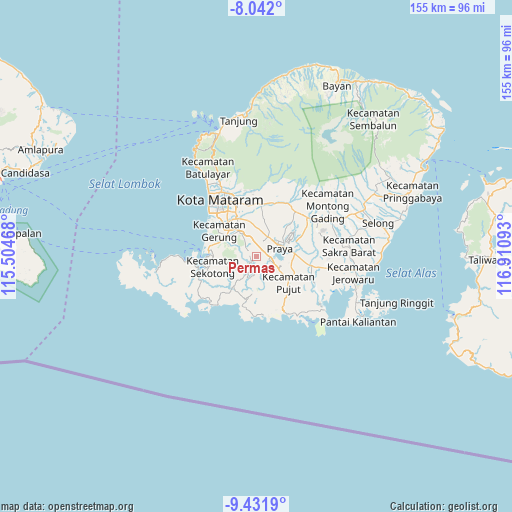
Permas GPS coordinates[2]
8° 44' 15.36" South, 116° 12' 28.08" East
| Map corner | latitude | longitude |
|---|---|---|
| Upper-left | -8.042°, | 115.50468° |
| Center: | -8.7376°, | 116.2078° |
| Lower-right: | -9.4319°, | 116.91093° |
| Map W x H: | 154.5×154.5 km | = 96×96mi |
| max Lat: | 5.88969° ⇑90.1% North |
| Permas: | -8.7376° |
| min Lat: | ⇓9.9% South -10.934° |
| min Long | Permas | max Long |
| 95.1345° | 116.2078° | 140.9419° |
| W 76.4%⇐ | ⇒23.6% E |
Elevation
Elevation of Permas is 76 m = 249 ft, and this is 153.7 m = 504 ft below average elevation for this country.
| Max E: |
3185 m = 10449 ft | 56.5% |
| Avg. | 229.7 m = 754 ft | |
| Permas | 76 m = 249 ft | |
Min E: |
-1 m = -3 ft | 43.5% |
See also: Indonesia elevation on elevation.city.
Geographical zone
Permas is located in South Torrid zone (between Equator and Tropic of Capricorn). Distance of Equator is 971.5 km =603.7 mi to North.| Distance of | km | miles | from Permas |
|---|---|---|---|
| Equator | 971.5 | 603.7 | to North |
| Tropic Capricorn | 1634.4 | 1015.6 | to South |
| Antarctic Circle | 6429.6 | 3995.2 | to South |
| South Pole | 9035.5 | 5614.4 | to South |


Nearby cities:
15 places around Permas: (largest is in red/bold)
• Ampanlolat
2.2 km =1.4 mi,  332°
332°
• Bangekdewa
2.1 km =1.3 mi,  237°
237°
• Barejulat
10 km =6.2 mi,  29°
29°
• Batutulis
5.2 km =3.2 mi,  7°
7°
• Blong Daye
5.3 km =3.3 mi,  21°
21°
• Karang Daye
3.8 km =2.4 mi,  102°
102°
• Karangdalam
3.9 km =2.4 mi,  91°
91°
• Ketara
9.8 km =6.1 mi,  125°
125°
• Pendaleman
6.9 km =4.3 mi, 31°
• Pengembur Dua
9.8 km =6.1 mi,  142°
142°
• Penunjak
3.6 km =2.2 mi, 103°
• Praya
7.8 km =4.8 mi,  62°
62°
• Ranggagata
3 km =1.9 mi,  303°
303°
• Semayan
8.6 km =5.3 mi,  76°
76°
• Tanakawu Dua
7.7 km =4.8 mi,  121°
121°
Sources, notices
• [Note1] Compared only with cities in Indonesia existing in our database
• [Src1] Map data: © OpenStreetMap contributors (CC-BY-SA)
• [Src2] Other city data from geonames.org with taken over terms of usage.
• [Src3] Geographical zone / Annual Mean Temperature by Robert A. Rohde @ Wikipedia
