Jelateng Timur geodata
Jelateng Timur (West Nusa Tenggara) is a seat of a fourth-order administrative division; located in Indonesia in Asia/Makassar (GMT+8) time zone. In our database, there are 407 cities with bigger population. Compared to other cities in Indonesia, 90.5% of cities are located further ↑North; 76% of cities are located further ←West and 75.5% of cities have higher elevation than Jelateng Timur. Note1


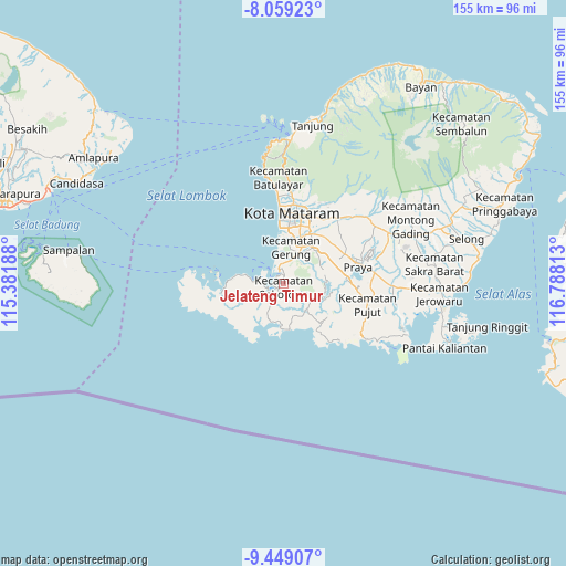
Jelateng Timur GPS coordinates[2]
8° 45' 17.28" South, 116° 5' 6" East
| Map corner | latitude | longitude |
|---|---|---|
| Upper-left | -8.05923°, | 115.38188° |
| Center: | -8.7548°, | 116.085° |
| Lower-right: | -9.44907°, | 116.78813° |
| Map W x H: | 154.5×154.5 km | = 96×96mi |
| max Lat: | 5.88969° ⇑90.5% North |
| Jelateng Timur: | -8.7548° |
| min Lat: | ⇓9.5% South -10.934° |
| min Long | Jelateng Timur | max Long |
| 95.1345° | 116.085° | 140.9419° |
| W 76%⇐ | ⇒24% E |
Elevation
Elevation of Jelateng Timur is 24 m = 79 ft, and this is 205.7 m = 675 ft below average elevation for this country.
| Max E: |
3185 m = 10449 ft | 75.5% |
| Avg. | 229.7 m = 754 ft | |
| Jelateng Timur | 24 m = 79 ft | |
Min E: |
-1 m = -3 ft | 24.5% |
See also: Indonesia elevation on elevation.city.
Geographical zone
Jelateng Timur is located in South Torrid zone (between Equator and Tropic of Capricorn). Distance of Equator is 973.4 km =604.8 mi to North.| Distance of | km | miles | from Jelateng Timur |
|---|---|---|---|
| Equator | 973.4 | 604.8 | to North |
| Tropic Capricorn | 1632.5 | 1014.4 | to South |
| Antarctic Circle | 6427.7 | 3994 | to South |
| South Pole | 9033.6 | 5613.2 | to South |


Nearby cities:
15 places around Jelateng Timur: (largest is in red/bold)
• Ampanlolat
13 km =8.1 mi,  72°
72°
• Bangekdewa
11.8 km =7.3 mi,  86°
86°
• Batutulis
15.8 km =9.8 mi,  63°
63°
• Bengkel Utara
16.9 km =10.5 mi,  24°
24°
• Blong Daye
16.9 km =10.5 mi, 66°
• Gerung
9.1 km =5.7 mi,  29°
29°
• Karang Kuripan
15.4 km =9.6 mi, 29°
• Karangkebon Timur
15.3 km =9.5 mi, 22°
• Kediri
15.3 km =9.5 mi, 28°
• Lembar
3.4 km =2.1 mi,  339°
339°
• Penunjak
17.1 km =10.6 mi, 86°
• Permas
13.6 km =8.5 mi,  81°
81°
• Ranggagata
11.5 km =7.1 mi, 71°
• Sekotong Tengah
4.8 km =3 mi,  237°
237°
• Tawun
8.5 km =5.3 mi,  271°
271°
Sources, notices
• [Note1] Compared only with cities in Indonesia existing in our database
• [Src1] Map data: © OpenStreetMap contributors (CC-BY-SA)
• [Src2] Other city data from geonames.org with taken over terms of usage.
• [Src3] Geographical zone / Annual Mean Temperature by Robert A. Rohde @ Wikipedia
