Kepahiang geodata
Kepahiang (Bengkulu) is a seat of a second-order administrative division; located in Indonesia in Asia/Jakarta (GMT+7) time zone. In our database, there are 407 cities with bigger population. Compared to other cities in Indonesia, 90.1% of cities are located further ↓South; 95.9% of cities are located further →East and 83.9% of cities have lower elevation than Kepahiang. Note1


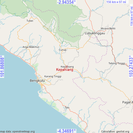
Kepahiang GPS coordinates[2]
3° 38' 43.8" South, 102° 34' 16.32" East
| Map corner | latitude | longitude |
|---|---|---|
| Upper-left | -2.94354°, | 101.86808° |
| Center: | -3.6455°, | 102.5712° |
| Lower-right: | -4.34691°, | 103.27433° |
| Map W x H: | 156×156 km | = 96.9×96.9mi |
| max Lat: | 5.88969° ⇑9.9% North |
| Kepahiang: | -3.6455° |
| min Lat: | ⇓90.1% South -10.934° |
| min Long | Kepahiang | max Long |
| 95.1345° | 102.5712° | 140.9419° |
| W 4.1%⇐ | ⇒95.9% E |
Elevation
Elevation of Kepahiang is 498 m = 1634 ft, and this is 268.3 m = 880 ft above average elevation for this country.
| Max E: |
3185 m = 10449 ft | 16.1% |
| Kepahiang | 498 m 1634 ft | |
| Avg. | 229.7 m = 754 ft | |
Min E: |
-1 m = -3 ft | 83.9% |
See also: Indonesia elevation on elevation.city.
Geographical zone
Kepahiang is located in South Torrid zone (between Equator and Tropic of Capricorn). Distance of Equator is 405.3 km =251.8 mi to North.| Distance of | km | miles | from Kepahiang |
|---|---|---|---|
| Equator | 405.3 | 251.8 | to North |
| Tropic Capricorn | 2200.6 | 1367.4 | to South |
| Antarctic Circle | 6995.8 | 4347 | to South |
| South Pole | 9601.7 | 5966.2 | to South |


Nearby cities:
15 places around Kepahiang: (largest is in red/bold)
• Argamakmur
49.1 km =30.5 mi,  300°
300°
• Bengkulu
38 km =23.6 mi,  243°
243°
• Curup
20.3 km =12.6 mi,  343°
343°
• Karang Tinggi
20.2 km =12.6 mi,  234°
234°
• Lais
59.3 km =36.8 mi,  282°
282°
• Lubuklinggau
50.6 km =31.4 mi,  39°
39°
• Masmambang
59.4 km =36.9 mi,  166°
166°
• Muara Beliti
67.7 km =42.1 mi,  49°
49°
• Muarapinang
58.1 km =36.1 mi,  113°
113°
• Padangtepung
27.5 km =17.1 mi,  115°
115°
• Padangulaktanding
39.3 km =24.4 mi, 40°
• Tais
47.8 km =29.7 mi,  179°
179°
• Tebing Tinggi
56.6 km =35.2 mi,  83°
83°
• Terawas
71.3 km =44.3 mi,  22°
22°
• Tubei
71.6 km =44.5 mi,  324°
324°
Sources, notices
• [Note1] Compared only with cities in Indonesia existing in our database
• [Src1] Map data: © OpenStreetMap contributors (CC-BY-SA)
• [Src2] Other city data from geonames.org with taken over terms of usage.
• [Src3] Geographical zone / Annual Mean Temperature by Robert A. Rohde @ Wikipedia
