Lubuklinggau geodata
Lubuklinggau (South Sumatra) is a seat of a second-order administrative division; located in Indonesia in Asia/Jakarta (GMT+7) time zone. With population of 148,243 people, there are 77 cities with bigger population in this country. Compared to other cities in Indonesia, 90.7% of cities are located further ↓South; 95.8% of cities are located further →East and 57.3% of cities have lower elevation than Lubuklinggau. Note1


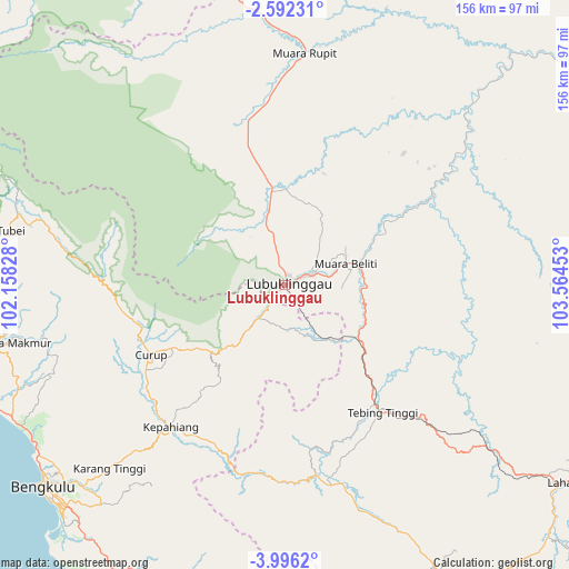
Lubuklinggau GPS coordinates[2]
3° 17' 40.2" South, 102° 51' 41.04" East
| Map corner | latitude | longitude |
|---|---|---|
| Upper-left | -2.59231°, | 102.15828° |
| Center: | -3.2945°, | 102.8614° |
| Lower-right: | -3.9962°, | 103.56453° |
| Map W x H: | 156.1×156.1 km | = 97×97mi |
| max Lat: | 5.88969° ⇑9.3% North |
| Lubuklinggau: | -3.2945° |
| min Lat: | ⇓90.7% South -10.934° |
| min Long | Lubuklinggau | max Long |
| 95.1345° | 102.8614° | 140.9419° |
| W 4.2%⇐ | ⇒95.8% E |
Elevation
Elevation of Lubuklinggau is 140 m = 459 ft, and this is 89.7 m = 294 ft below average elevation for this country.
| Max E: |
3185 m = 10449 ft | 42.7% |
| Avg. | 229.7 m = 754 ft | |
| Lubuklinggau | 140 m = 459 ft | |
Min E: |
-1 m = -3 ft | 57.3% |
See also: Lubuklinggau elevation on elevation.city.
Geographical zone
Lubuklinggau is located in South Torrid zone (between Equator and Tropic of Capricorn). Distance of Equator is 366.3 km =227.6 mi to North.| Distance of | km | miles | from Lubuklinggau |
|---|---|---|---|
| Equator | 366.3 | 227.6 | to North |
| Tropic Capricorn | 2239.6 | 1391.6 | to South |
| Antarctic Circle | 7034.9 | 4371.3 | to South |
| South Pole | 9640.7 | 5990.5 | to South |


Nearby cities:
15 places around Lubuklinggau: (largest is in red/bold)
• Argamakmur
76 km =47.2 mi,  259°
259°
• Bunga Mas
72.2 km =44.9 mi,  128°
128°
• Curup
42.6 km =26.5 mi,  242°
242°
• Karang Tinggi
70.3 km =43.7 mi,  223°
223°
• Kepahiang
50.6 km =31.4 mi, 219°
• Muara Beliti
19.8 km =12.3 mi,  75°
75°
• Muaralakitan
69 km =42.9 mi,  45°
45°
• Muarapinang
65.4 km =40.6 mi,  160°
160°
• Muararupit
63.7 km =39.6 mi,  4°
4°
• Padangtepung
51.6 km =32.1 mi,  188°
188°
• Padangulaktanding
11.3 km =7 mi, 217°
• Surulangun Rawas
75.5 km =46.9 mi,  351°
351°
• Tebing Tinggi
40.1 km =24.9 mi,  143°
143°
• Terawas
27.4 km =17 mi, 349°
• Tubei
76 km =47.2 mi,  284°
284°
Sources, notices
• [Note1] Compared only with cities in Indonesia existing in our database
• [Src1] Map data: © OpenStreetMap contributors (CC-BY-SA)
• [Src2] Other city data from geonames.org with taken over terms of usage.
• [Src3] Geographical zone / Annual Mean Temperature by Robert A. Rohde @ Wikipedia
