Curup geodata
Curup (Bengkulu) is a seat of a second-order administrative division; located in Indonesia in Asia/Jakarta (GMT+7) time zone. With population of 46,245 people, there are 249 cities with bigger population in this country. Compared to other cities in Indonesia, 90.3% of cities are located further ↓South; 95.9% of cities are located further →East and 89.7% of cities have lower elevation than Curup. Note1


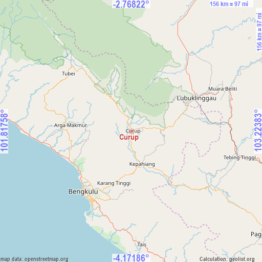
Curup GPS coordinates[2]
3° 28' 13.08" South, 102° 31' 14.52" East
| Map corner | latitude | longitude |
|---|---|---|
| Upper-left | -2.76822°, | 101.81758° |
| Center: | -3.4703°, | 102.5207° |
| Lower-right: | -4.17186°, | 103.22383° |
| Map W x H: | 156.1×156.1 km | = 97×97mi |
| max Lat: | 5.88969° ⇑9.7% North |
| Curup: | -3.4703° |
| min Lat: | ⇓90.3% South -10.934° |
| min Long | Curup | max Long |
| 95.1345° | 102.5207° | 140.9419° |
| W 4.1%⇐ | ⇒95.9% E |
Elevation
Elevation of Curup is 630 m = 2067 ft, and this is 400.3 m = 1313 ft above average elevation for this country.
| Max E: |
3185 m = 10449 ft | 10.3% |
| Curup | 630 m 2067 ft | |
| Avg. | 229.7 m = 754 ft | |
Min E: |
-1 m = -3 ft | 89.7% |
See also: Curup elevation on elevation.city.
Geographical zone
Curup is located in South Torrid zone (between Equator and Tropic of Capricorn). Distance of Equator is 385.9 km =239.8 mi to North.| Distance of | km | miles | from Curup |
|---|---|---|---|
| Equator | 385.9 | 239.8 | to North |
| Tropic Capricorn | 2220.1 | 1379.5 | to South |
| Antarctic Circle | 7015.3 | 4359.1 | to South |
| South Pole | 9621.2 | 5978.3 | to South |


Nearby cities:
15 places around Curup: (largest is in red/bold)
• Argamakmur
37.2 km =23.1 mi,  278°
278°
• Bengkulu
46.4 km =28.8 mi,  217°
217°
• Karang Tinggi
33 km =20.5 mi,  199°
199°
• Kepahiang
20.3 km =12.6 mi,  163°
163°
• Ketahun
76.6 km =47.6 mi, 276°
• Lais
52.7 km =32.7 mi,  262°
262°
• Lubuklinggau
42.6 km =26.5 mi,  62°
62°
• Muara Beliti
62 km =38.5 mi,  66°
66°
• Muarapinang
72.6 km =45.1 mi,  125°
125°
• Padangtepung
43.8 km =27.2 mi,  136°
136°
• Padangulaktanding
32.7 km =20.3 mi, 71°
• Tais
67.6 km =42 mi,  174°
174°
• Tebing Tinggi
63 km =39.1 mi,  101°
101°
• Terawas
56.8 km =35.3 mi,  35°
35°
• Tubei
52.8 km =32.8 mi,  317°
317°
Sources, notices
• [Note1] Compared only with cities in Indonesia existing in our database
• [Src1] Map data: © OpenStreetMap contributors (CC-BY-SA)
• [Src2] Other city data from geonames.org with taken over terms of usage.
• [Src3] Geographical zone / Annual Mean Temperature by Robert A. Rohde @ Wikipedia
