Hampang geodata
Hampang (South Kalimantan) is a seat of a third-order administrative division; located in Indonesia in Asia/Makassar (GMT+8) time zone. In our database, there are 407 cities with bigger population. Compared to other cities in Indonesia, 91.4% of cities are located further ↓South; 75.8% of cities are located further ←West and 59.6% of cities have higher elevation than Hampang. Note1


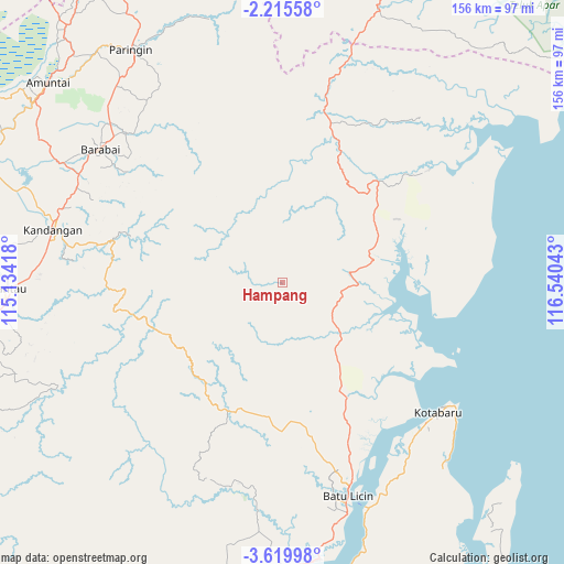
Hampang GPS coordinates[2]
2° 55' 4.8" South, 115° 50' 14.28" East
| Map corner | latitude | longitude |
|---|---|---|
| Upper-left | -2.21558°, | 115.13418° |
| Center: | -2.918°, | 115.8373° |
| Lower-right: | -3.61998°, | 116.54043° |
| Map W x H: | 156.2×156.2 km | = 97.1×97.1mi |
| max Lat: | 5.88969° ⇑8.6% North |
| Hampang: | -2.918° |
| min Lat: | ⇓91.4% South -10.934° |
| min Long | Hampang | max Long |
| 95.1345° | 115.8373° | 140.9419° |
| W 75.8%⇐ | ⇒24.2% E |
Elevation
Elevation of Hampang is 61 m = 200 ft, and this is 168.7 m = 553 ft below average elevation for this country.
| Max E: |
3185 m = 10449 ft | 59.6% |
| Avg. | 229.7 m = 754 ft | |
| Hampang | 61 m = 200 ft | |
Min E: |
-1 m = -3 ft | 40.4% |
See also: Indonesia elevation on elevation.city.
Geographical zone
Hampang is located in South Torrid zone (between Equator and Tropic of Capricorn). Distance of Equator is 324.5 km =201.6 mi to North.| Distance of | km | miles | from Hampang |
|---|---|---|---|
| Equator | 324.5 | 201.6 | to North |
| Tropic Capricorn | 2281.5 | 1417.7 | to South |
| Antarctic Circle | 7076.7 | 4397.3 | to South |
| South Pole | 9682.6 | 6016.5 | to South |


Nearby cities:
15 places around Hampang: (largest is in red/bold)
• Awayan
54.6 km =33.9 mi,  338°
338°
• Batulicin
58.9 km =36.6 mi,  161°
161°
• Belimbing
54.6 km =33.9 mi,  262°
262°
• Birayang
60.3 km =37.5 mi,  315°
315°
• Haruyan
59.7 km =37.1 mi,  294°
294°
• Kotabaru Hilir
56.2 km =34.9 mi,  129°
129°
• Loklaga
56.4 km =35 mi, 293°
• Manunggulama
57.8 km =35.9 mi,  39°
39°
• Pagat
55.4 km =34.4 mi,  306°
306°
• Pantai
40.7 km =25.3 mi, 125°
• Pudi
56.3 km =35 mi,  86°
86°
• Stagen
57.3 km =35.6 mi,  138°
138°
• Sungaikupang
22.1 km =13.7 mi, 129°
• Tanjungbatu
43.8 km =27.2 mi,  102°
102°
• Telagalangsat
33.5 km =20.8 mi,  295°
295°
Sources, notices
• [Note1] Compared only with cities in Indonesia existing in our database
• [Src1] Map data: © OpenStreetMap contributors (CC-BY-SA)
• [Src2] Other city data from geonames.org with taken over terms of usage.
• [Src3] Geographical zone / Annual Mean Temperature by Robert A. Rohde @ Wikipedia
