Stagen geodata
Stagen (South Kalimantan) is a seat of a third-order administrative division; located in Indonesia in Asia/Makassar (GMT+8) time zone. In our database, there are 407 cities with bigger population. Compared to other cities in Indonesia, 90.7% of cities are located further ↓South; 76.2% of cities are located further ←West and 62.8% of cities have higher elevation than Stagen. Note1


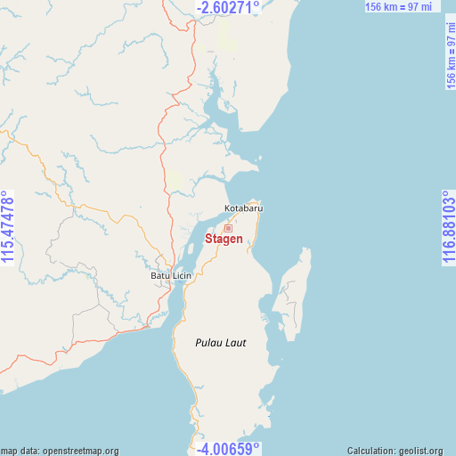
Stagen GPS coordinates[2]
3° 18' 17.64" South, 116° 10' 40.44" East
| Map corner | latitude | longitude |
|---|---|---|
| Upper-left | -2.60271°, | 115.47478° |
| Center: | -3.3049°, | 116.1779° |
| Lower-right: | -4.00659°, | 116.88103° |
| Map W x H: | 156.1×156.1 km | = 97×97mi |
| max Lat: | 5.88969° ⇑9.3% North |
| Stagen: | -3.3049° |
| min Lat: | ⇓90.7% South -10.934° |
| min Long | Stagen | max Long |
| 95.1345° | 116.1779° | 140.9419° |
| W 76.2%⇐ | ⇒23.8% E |
Elevation
Elevation of Stagen is 49 m = 161 ft, and this is 180.7 m = 593 ft below average elevation for this country.
| Max E: |
3185 m = 10449 ft | 62.8% |
| Avg. | 229.7 m = 754 ft | |
| Stagen | 49 m = 161 ft | |
Min E: |
-1 m = -3 ft | 37.2% |
See also: Indonesia elevation on elevation.city.
Geographical zone
Stagen is located in South Torrid zone (between Equator and Tropic of Capricorn). Distance of Equator is 367.5 km =228.4 mi to North.| Distance of | km | miles | from Stagen |
|---|---|---|---|
| Equator | 367.5 | 228.4 | to North |
| Tropic Capricorn | 2238.4 | 1390.9 | to South |
| Antarctic Circle | 7033.7 | 4370.5 | to South |
| South Pole | 9639.6 | 5989.8 | to South |


Nearby cities:
15 places around Stagen: (largest is in red/bold)
• Allealle
68.9 km =42.8 mi,  168°
168°
• Batulicin
23 km =14.3 mi,  236°
236°
• Binawara
47 km =29.2 mi, 244°
• Gunungbatubesar
77.1 km =47.9 mi,  9°
9°
• Hampang
57.3 km =35.6 mi,  318°
318°
• Kotabaru Hilir
8.7 km =5.4 mi,  37°
37°
• Lontar
75.5 km =46.9 mi,  189°
189°
• Manunggulama
87.9 km =54.6 mi,  359°
359°
• Pagatan
42.9 km =26.7 mi,  218°
218°
• Pantai
19.9 km =12.4 mi,  346°
346°
• Pudi
49.9 km =31 mi,  21°
21°
• Sungaibali
27.4 km =17 mi,  113°
113°
• Sungaikupang
35.6 km =22.1 mi, 324°
• Tanjungbatu
34.2 km =21.3 mi, 8°
• Tanjungsamalantakan
84.4 km =52.4 mi, 17°
Sources, notices
• [Note1] Compared only with cities in Indonesia existing in our database
• [Src1] Map data: © OpenStreetMap contributors (CC-BY-SA)
• [Src2] Other city data from geonames.org with taken over terms of usage.
• [Src3] Geographical zone / Annual Mean Temperature by Robert A. Rohde @ Wikipedia
