Krocok geodata
Krocok (Central Java) is a seat of a fourth-order administrative division; located in Indonesia in Asia/Jakarta (GMT+7) time zone. In our database, there are 407 cities with bigger population. Compared to other cities in Indonesia, 68.1% of cities are located further ↓South; 61.9% of cities are located further →East and 54.5% of cities have lower elevation than Krocok. Note1


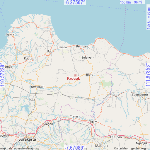
Krocok GPS coordinates[2]
6° 58' 24.6" South, 111° 16' 31.44" East
| Map corner | latitude | longitude |
|---|---|---|
| Upper-left | -6.27507°, | 110.57228° |
| Center: | -6.9735°, | 111.2754° |
| Lower-right: | -7.67089°, | 111.97853° |
| Map W x H: | 155.2×155.2 km | = 96.4×96.4mi |
| max Lat: | 5.88969° ⇑31.9% North |
| Krocok: | -6.9735° |
| min Lat: | ⇓68.1% South -10.934° |
| min Long | Krocok | max Long |
| 95.1345° | 111.2754° | 140.9419° |
| W 38.1%⇐ | ⇒61.9% E |
Elevation
Elevation of Krocok is 122 m = 400 ft, and this is 107.7 m = 353 ft below average elevation for this country.
| Max E: |
3185 m = 10449 ft | 45.5% |
| Avg. | 229.7 m = 754 ft | |
| Krocok | 122 m = 400 ft | |
Min E: |
-1 m = -3 ft | 54.5% |
See also: Indonesia elevation on elevation.city.
Geographical zone
Krocok is located in South Torrid zone (between Equator and Tropic of Capricorn). Distance of Equator is 775.4 km =481.8 mi to North.| Distance of | km | miles | from Krocok |
|---|---|---|---|
| Equator | 775.4 | 481.8 | to North |
| Tropic Capricorn | 1830.5 | 1137.4 | to South |
| Antarctic Circle | 6625.8 | 4117.1 | to South |
| South Pole | 9231.7 | 5736.3 | to South |


Nearby cities:
15 places around Krocok: (largest is in red/bold)
• Balong Wetan
3.4 km =2.1 mi,  207°
207°
• Beganjing
3 km =1.9 mi,  52°
52°
• Bradag
3.1 km =1.9 mi,  135°
135°
• Gotputuk
3.8 km =2.4 mi,  117°
117°
• Japah
3.8 km =2.4 mi,  25°
25°
• Ngrambitan
3.7 km =2.3 mi,  71°
71°
• Padaan
4.3 km =2.7 mi,  38°
38°
• Pecaren
4.6 km =2.9 mi, 143°
• Pelem
2.1 km =1.3 mi,  244°
244°
• Plosorejo
2.6 km =1.6 mi,  217°
217°
• Pulo
4.3 km =2.7 mi,  336°
336°
• Sambongrejo
4.6 km =2.9 mi,  97°
97°
• Suren
3.1 km =1.9 mi,  89°
89°
• Tengger
2.8 km =1.7 mi, 118°
• Tlogowungu
4.6 km =2.9 mi,  4°
4°
Sources, notices
• [Note1] Compared only with cities in Indonesia existing in our database
• [Src1] Map data: © OpenStreetMap contributors (CC-BY-SA)
• [Src2] Other city data from geonames.org with taken over terms of usage.
• [Src3] Geographical zone / Annual Mean Temperature by Robert A. Rohde @ Wikipedia
