Telagaselaba geodata
Telagaselaba (South Kalimantan) is a seat of a third-order administrative division; located in Indonesia in Asia/Makassar (GMT+8) time zone. In our database, there are 407 cities with bigger population. Compared to other cities in Indonesia, 92.4% of cities are located further ↓South; 73.7% of cities are located further ←West and 89% of cities have higher elevation than Telagaselaba. Note1


Telagaselaba GPS coordinates[2]
2° 22' 58.44" South, 115° 18' 51.84" East
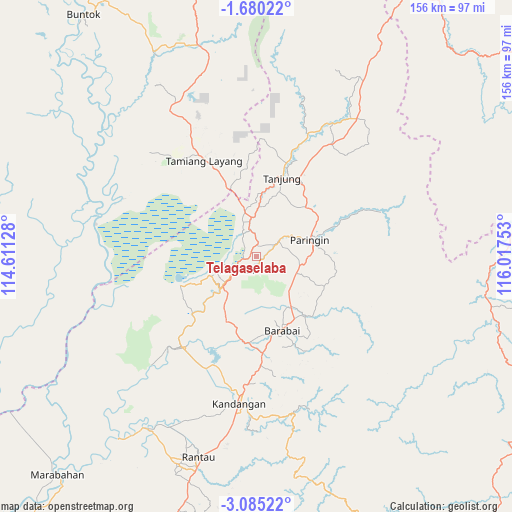
| Map corner | latitude | longitude |
|---|---|---|
| Upper-left | -1.68022°, | 114.61128° |
| Center: | -2.3829°, | 115.3144° |
| Lower-right: | -3.08522°, | 116.01753° |
| Map W x H: | 156.2×156.2 km | = 97.1×97.1mi |
| max Lat: | 5.88969° ⇑7.6% North |
| Telagaselaba: | -2.3829° |
| min Lat: | ⇓92.4% South -10.934° |
| min Long | Telagaselaba | max Long |
| 95.1345° | 115.3144° | 140.9419° |
| W 73.7%⇐ | ⇒26.3% E |
Elevation
Elevation of Telagaselaba is 11 m = 36 ft, and this is 218.7 m = 718 ft below average elevation for this country.
| Max E: |
3185 m = 10449 ft | 89% |
| Avg. | 229.7 m = 754 ft | |
| Telagaselaba | 11 m = 36 ft | |
Min E: |
-1 m = -3 ft | 11% |
See also: Indonesia elevation on elevation.city.
Geographical zone
Telagaselaba is located in South Torrid zone (between Equator and Tropic of Capricorn). Distance of Equator is 265 km =164.7 mi to North.| Distance of | km | miles | from Telagaselaba |
|---|---|---|---|
| Equator | 265 | 164.7 | to North |
| Tropic Capricorn | 2341 | 1454.6 | to South |
| Antarctic Circle | 7136.2 | 4434.2 | to South |
| South Pole | 9742.1 | 6053.5 | to South |


Nearby cities:
15 places around Telagaselaba: (largest is in red/bold)
• Alabio
11.1 km =6.9 mi,  224°
224°
• Alung
19.4 km =12.1 mi,  139°
139°
• Amuntai
8.2 km =5.1 mi,  241°
241°
• Babirik
24.6 km =15.3 mi, 224°
• Barabai
23.6 km =14.7 mi,  161°
161°
• Batumandi
14.7 km =9.1 mi,  107°
107°
• Birayang
22.8 km =14.2 mi, 136°
• Kelua
21.9 km =13.6 mi,  25°
25°
• Lampihung
23.7 km =14.7 mi,  89°
89°
• Paringin
18.6 km =11.6 mi,  73°
73°
• Pasararba
13.8 km =8.6 mi,  1°
1°
• Pendawanbaru
18.3 km =11.4 mi,  206°
206°
• Putatbasiun
24.2 km =15 mi,  99°
99°
• Sungaiturak
8.7 km =5.4 mi, 67°
• Tanta
23 km =14.3 mi,  41°
41°
Sources, notices
• [Note1] Compared only with cities in Indonesia existing in our database
• [Src1] Map data: © OpenStreetMap contributors (CC-BY-SA)
• [Src2] Other city data from geonames.org with taken over terms of usage.
• [Src3] Geographical zone / Annual Mean Temperature by Robert A. Rohde @ Wikipedia
