Bintuhan geodata
Bintuhan (Bengkulu) is a seat of a second-order administrative division; located in Indonesia in Asia/Jakarta (GMT+7) time zone. In our database, there are 407 cities with bigger population. Compared to other cities in Indonesia, 88.8% of cities are located further ↓South; 95.5% of cities are located further →East and 92.1% of cities have higher elevation than Bintuhan. Note1


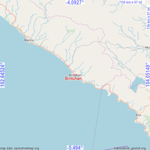
Bintuhan GPS coordinates[2]
4° 47' 37.356" South, 103° 20' 54.096" East
| Map corner | latitude | longitude |
|---|---|---|
| Upper-left | -4.0927°, | 102.64524° |
| Center: | -4.79371°, | 103.34836° |
| Lower-right: | -5.494°, | 104.05149° |
| Map W x H: | 155.8×155.8 km | = 96.8×96.8mi |
| max Lat: | 5.88969° ⇑11.2% North |
| Bintuhan: | -4.79371° |
| min Lat: | ⇓88.8% South -10.934° |
| min Long | Bintuhan | max Long |
| 95.1345° | 103.34836° | 140.9419° |
| W 4.5%⇐ | ⇒95.5% E |
Elevation
Elevation of Bintuhan is 9 m = 30 ft, and this is 220.7 m = 724 ft below average elevation for this country.
| Max E: |
3185 m = 10449 ft | 92.1% |
| Avg. | 229.7 m = 754 ft | |
| Bintuhan | 9 m = 30 ft | |
Min E: |
-1 m = -3 ft | 7.9% |
See also: Indonesia elevation on elevation.city.
Geographical zone
Bintuhan is located in South Torrid zone (between Equator and Tropic of Capricorn). Distance of Equator is 533 km =331.2 mi to North.| Distance of | km | miles | from Bintuhan |
|---|---|---|---|
| Equator | 533 | 331.2 | to North |
| Tropic Capricorn | 2072.9 | 1288 | to South |
| Antarctic Circle | 6868.2 | 4267.7 | to South |
| South Pole | 9474.1 | 5886.9 | to South |


Nearby cities:
15 places around Bintuhan: (largest is in red/bold)
• Banding Agung
63.9 km =39.7 mi,  91°
91°
• Biha
96.1 km =59.7 mi,  128°
128°
• Kenali
96.1 km =59.7 mi,  103°
103°
• Kotaagung
81.2 km =50.5 mi,  6°
6°
• Krui
78.3 km =48.7 mi,  123°
123°
• Kuripan
53.3 km =33.1 mi, 120°
• Liwa
85 km =52.8 mi,  108°
108°
• Manna
61.3 km =38.1 mi,  306°
306°
• Masat
63.4 km =39.4 mi,  316°
316°
• Muara Dua
85.5 km =53.1 mi,  70°
70°
• Muaradua
80.7 km =50.1 mi,  21°
21°
• Padangguci
32.1 km =19.9 mi, 315°
• Pagar Alam
86.2 km =53.6 mi,  352°
352°
• Pulauberingin
45.7 km =28.4 mi,  44°
44°
• Tanjungsakti
76.2 km =47.3 mi,  335°
335°
Sources, notices
• [Note1] Compared only with cities in Indonesia existing in our database
• [Src1] Map data: © OpenStreetMap contributors (CC-BY-SA)
• [Src2] Other city data from geonames.org with taken over terms of usage.
• [Src3] Geographical zone / Annual Mean Temperature by Robert A. Rohde @ Wikipedia
