Bama geodata
Bama (East Nusa Tenggara) is a seat of a fourth-order administrative division; located in Indonesia in Asia/Makassar (GMT+8) time zone. In our database, there are 407 cities with bigger population. Compared to other cities in Indonesia, 79.6% of cities are located further ↑North; 89.6% of cities are located further ←West and 74.1% of cities have higher elevation than Bama. Note1


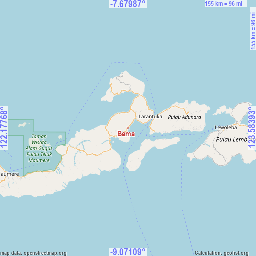
Bama GPS coordinates[2]
8° 22' 33.96" South, 122° 52' 50.88" East
| Map corner | latitude | longitude |
|---|---|---|
| Upper-left | -7.67987°, | 122.17768° |
| Center: | -8.3761°, | 122.8808° |
| Lower-right: | -9.07109°, | 123.58393° |
| Map W x H: | 154.7×154.7 km | = 96.1×96.1mi |
| max Lat: | 5.88969° ⇑79.6% North |
| Bama: | -8.3761° |
| min Lat: | ⇓20.4% South -10.934° |
| min Long | Bama | max Long |
| 95.1345° | 122.8808° | 140.9419° |
| W 89.6%⇐ | ⇒10.4% E |
Elevation
Elevation of Bama is 26 m = 85 ft, and this is 203.7 m = 668 ft below average elevation for this country.
| Max E: |
3185 m = 10449 ft | 74.1% |
| Avg. | 229.7 m = 754 ft | |
| Bama | 26 m = 85 ft | |
Min E: |
-1 m = -3 ft | 25.9% |
See also: Indonesia elevation on elevation.city.
Geographical zone
Bama is located in South Torrid zone (between Equator and Tropic of Capricorn). Distance of Equator is 931.3 km =578.7 mi to North.| Distance of | km | miles | from Bama |
|---|---|---|---|
| Equator | 931.3 | 578.7 | to North |
| Tropic Capricorn | 1674.6 | 1040.5 | to South |
| Antarctic Circle | 6469.8 | 4020.1 | to South |
| South Pole | 9075.7 | 5639.4 | to South |


Nearby cities:
15 places around Bama: (largest is in red/bold)
• Buri
7.6 km =4.7 mi,  257°
257°
• Eputobi
6.5 km =4 mi,  235°
235°
• Lamawalang
7.5 km =4.7 mi,  50°
50°
• Lamika
6.2 km =3.9 mi,  223°
223°
• Lewokluok
3.9 km =2.4 mi, 237°
• Lewolaga
9.2 km =5.7 mi, 238°
• Lewolere
9.2 km =5.7 mi,  70°
70°
• Lewoloba
8 km =5 mi,  43°
43°
• Leworook
6 km =3.7 mi, 258°
• Pantaibesar
10.1 km =6.3 mi, 72°
• Raganama
5.3 km =3.3 mi,  34°
34°
• Riangpedang
9.5 km =5.9 mi,  359°
359°
• Waibalun
8.8 km =5.5 mi, 67°
• Wailolong
8.4 km =5.2 mi, 36°
• Wolo
4.3 km =2.7 mi, 223°
Sources, notices
• [Note1] Compared only with cities in Indonesia existing in our database
• [Src1] Map data: © OpenStreetMap contributors (CC-BY-SA)
• [Src2] Other city data from geonames.org with taken over terms of usage.
• [Src3] Geographical zone / Annual Mean Temperature by Robert A. Rohde @ Wikipedia
