Buri geodata
Buri (East Nusa Tenggara) is a seat of a fourth-order administrative division; located in Indonesia in Asia/Makassar (GMT+8) time zone. In our database, there are 407 cities with bigger population. Compared to other cities in Indonesia, 80.1% of cities are located further ↑North; 89.4% of cities are located further ←West and 78.7% of cities have lower elevation than Buri. Note1


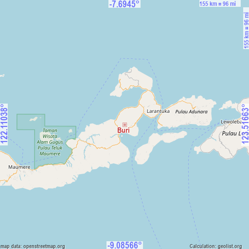
Buri GPS coordinates[2]
8° 23' 26.52" South, 122° 48' 48.6" East
| Map corner | latitude | longitude |
|---|---|---|
| Upper-left | -7.6945°, | 122.11038° |
| Center: | -8.3907°, | 122.8135° |
| Lower-right: | -9.08566°, | 123.51663° |
| Map W x H: | 154.7×154.7 km | = 96.1×96.1mi |
| max Lat: | 5.88969° ⇑80.1% North |
| Buri: | -8.3907° |
| min Lat: | ⇓19.9% South -10.934° |
| min Long | Buri | max Long |
| 95.1345° | 122.8135° | 140.9419° |
| W 89.4%⇐ | ⇒10.6% E |
Elevation
Elevation of Buri is 407 m = 1335 ft, and this is 177.3 m = 582 ft above average elevation for this country.
| Max E: |
3185 m = 10449 ft | 21.3% |
| Buri | 407 m 1335 ft | |
| Avg. | 229.7 m = 754 ft | |
Min E: |
-1 m = -3 ft | 78.7% |
See also: Indonesia elevation on elevation.city.
Geographical zone
Buri is located in South Torrid zone (between Equator and Tropic of Capricorn). Distance of Equator is 933 km =579.7 mi to North.| Distance of | km | miles | from Buri |
|---|---|---|---|
| Equator | 933 | 579.7 | to North |
| Tropic Capricorn | 1673 | 1039.6 | to South |
| Antarctic Circle | 6468.2 | 4019.2 | to South |
| South Pole | 9074.1 | 5638.4 | to South |


Nearby cities:
15 places around Buri: (largest is in red/bold)
• Bama
7.6 km =4.7 mi,  77°
77°
• Blaloudeng
2.8 km =1.7 mi,  250°
250°
• Eputobi
2.9 km =1.8 mi,  134°
134°
• Gerong
3.5 km =2.2 mi,  234°
234°
• Kanada
6.6 km =4.1 mi, 228°
• Konga
7.9 km =4.9 mi,  211°
211°
• Lamika
4.2 km =2.6 mi, 132°
• Lato
6.6 km =4.1 mi,  292°
292°
• Lewokluok
4.2 km =2.6 mi,  96°
96°
• Lewolaga
3.2 km =2 mi,  187°
187°
• Lewoluo
8.6 km =5.3 mi,  343°
343°
• Leworook
1.6 km =1 mi, 75°
• Nobo
10.8 km =6.7 mi, 194°
• Raganama
12 km =7.5 mi,  60°
60°
• Wolo
4.7 km =2.9 mi,  109°
109°
Sources, notices
• [Note1] Compared only with cities in Indonesia existing in our database
• [Src1] Map data: © OpenStreetMap contributors (CC-BY-SA)
• [Src2] Other city data from geonames.org with taken over terms of usage.
• [Src3] Geographical zone / Annual Mean Temperature by Robert A. Rohde @ Wikipedia
