Awipari Tengah geodata
Awipari Tengah (West Java) is a seat of a fourth-order administrative division; located in Indonesia in Asia/Jakarta (GMT+7) time zone. In our database, there are 407 cities with bigger population. Compared to other cities in Indonesia, 51.3% of cities are located further ↑North; 75.1% of cities are located further →East and 72.3% of cities have lower elevation than Awipari Tengah. Note1


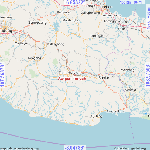
Awipari Tengah GPS coordinates[2]
7° 21' 3.96" South, 108° 16' 18.84" East
| Map corner | latitude | longitude |
|---|---|---|
| Upper-left | -6.65322°, | 107.56878° |
| Center: | -7.3511°, | 108.2719° |
| Lower-right: | -8.04788°, | 108.97503° |
| Map W x H: | 155.1×155.1 km | = 96.4×96.4mi |
| max Lat: | 5.88969° ⇑51.3% North |
| Awipari Tengah: | -7.3511° |
| min Lat: | ⇓48.7% South -10.934° |
| min Long | Awipari Tengah | max Long |
| 95.1345° | 108.2719° | 140.9419° |
| W 24.9%⇐ | ⇒75.1% E |
Elevation
Elevation of Awipari Tengah is 326 m = 1070 ft, and this is 96.3 m = 316 ft above average elevation for this country.
| Max E: |
3185 m = 10449 ft | 27.7% |
| Awipari Tengah | 326 m 1070 ft | |
| Avg. | 229.7 m = 754 ft | |
Min E: |
-1 m = -3 ft | 72.3% |
See also: Indonesia elevation on elevation.city.
Geographical zone
Awipari Tengah is located in South Torrid zone (between Equator and Tropic of Capricorn). Distance of Equator is 817.4 km =507.9 mi to North.| Distance of | km | miles | from Awipari Tengah |
|---|---|---|---|
| Equator | 817.4 | 507.9 | to North |
| Tropic Capricorn | 1788.6 | 1111.4 | to South |
| Antarctic Circle | 6583.8 | 4091 | to South |
| South Pole | 9189.7 | 5710.2 | to South |


Nearby cities:
15 places around Awipari Tengah: (largest is in red/bold)
• Bantargedang
2.6 km =1.6 mi,  251°
251°
• Bojongnangka
3.2 km =2 mi,  311°
311°
• Cibangun Tengah
1.2 km =0.7 mi,  216°
216°
• Cibeureum
0.5 km =0.3 mi,  212°
212°
• Cimuncang
2.9 km =1.8 mi,  110°
110°
• Condong
1.6 km =1 mi,  296°
296°
• Gerempay
2.3 km =1.4 mi,  50°
50°
• Gunajaya
2.4 km =1.5 mi,  167°
167°
• Kadupandak
3.1 km =1.9 mi, 223°
• Kertasari
1.2 km =0.7 mi,  62°
62°
• Kotabaru
1.3 km =0.8 mi, 252°
• Lemburwarung
2 km =1.2 mi,  330°
330°
• Pasirjaya
2.9 km =1.8 mi,  351°
351°
• Sukasirna
1.7 km =1.1 mi,  157°
157°
• Walagar
1.9 km =1.2 mi,  95°
95°
Sources, notices
• [Note1] Compared only with cities in Indonesia existing in our database
• [Src1] Map data: © OpenStreetMap contributors (CC-BY-SA)
• [Src2] Other city data from geonames.org with taken over terms of usage.
• [Src3] Geographical zone / Annual Mean Temperature by Robert A. Rohde @ Wikipedia
