Kadupandak geodata
Kadupandak (West Java) is a seat of a fourth-order administrative division; located in Indonesia in Asia/Jakarta (GMT+7) time zone. In our database, there are 407 cities with bigger population. Compared to other cities in Indonesia, 52.2% of cities are located further ↑North; 75.5% of cities are located further →East and 75.7% of cities have lower elevation than Kadupandak. Note1


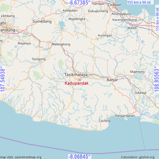
Kadupandak GPS coordinates[2]
7° 22' 18.12" South, 108° 15' 9" East
| Map corner | latitude | longitude |
|---|---|---|
| Upper-left | -6.67385°, | 107.54938° |
| Center: | -7.3717°, | 108.2525° |
| Lower-right: | -8.06845°, | 108.95563° |
| Map W x H: | 155.1×155.1 km | = 96.4×96.4mi |
| max Lat: | 5.88969° ⇑52.2% North |
| Kadupandak: | -7.3717° |
| min Lat: | ⇓47.8% South -10.934° |
| min Long | Kadupandak | max Long |
| 95.1345° | 108.2525° | 140.9419° |
| W 24.5%⇐ | ⇒75.5% E |
Elevation
Elevation of Kadupandak is 368 m = 1207 ft, and this is 138.3 m = 454 ft above average elevation for this country.
| Max E: |
3185 m = 10449 ft | 24.3% |
| Kadupandak | 368 m 1207 ft | |
| Avg. | 229.7 m = 754 ft | |
Min E: |
-1 m = -3 ft | 75.7% |
See also: Indonesia elevation on elevation.city.
Geographical zone
Kadupandak is located in South Torrid zone (between Equator and Tropic of Capricorn). Distance of Equator is 819.7 km =509.3 mi to North.| Distance of | km | miles | from Kadupandak |
|---|---|---|---|
| Equator | 819.7 | 509.3 | to North |
| Tropic Capricorn | 1786.3 | 1110 | to South |
| Antarctic Circle | 6581.5 | 4089.6 | to South |
| South Pole | 9187.4 | 5708.8 | to South |


Nearby cities:
15 places around Kadupandak: (largest is in red/bold)
• Awipari Tengah
3.1 km =1.9 mi,  43°
43°
• Bandung
3.2 km =2 mi,  163°
163°
• Bantargedang
1.5 km =0.9 mi,  348°
348°
• Cibangun Tengah
2 km =1.2 mi,  46°
46°
• Cibeureum
2.6 km =1.6 mi, 45°
• Cibeureum
2.6 km =1.6 mi,  228°
228°
• Condong
3.1 km =1.9 mi,  13°
13°
• Gegernoong
2.7 km =1.7 mi, 234°
• Gunajaya
2.6 km =1.6 mi,  90°
90°
• Gunungmuncang
2.8 km =1.7 mi,  325°
325°
• Jatiwangi
1 km =0.6 mi,  141°
141°
• Kotabaru
2.1 km =1.3 mi,  24°
24°
• Rahayu Dua
1.9 km =1.2 mi,  268°
268°
• Sukamaju
2.8 km =1.7 mi, 271°
• Sukasirna
2.9 km =1.8 mi,  76°
76°
Sources, notices
• [Note1] Compared only with cities in Indonesia existing in our database
• [Src1] Map data: © OpenStreetMap contributors (CC-BY-SA)
• [Src2] Other city data from geonames.org with taken over terms of usage.
• [Src3] Geographical zone / Annual Mean Temperature by Robert A. Rohde @ Wikipedia
