Atambua geodata
Atambua (East Nusa Tenggara) is a seat of a second-order administrative division; located in Indonesia in Asia/Makassar (GMT+8) time zone. With population of 35,793 people, there are 285 cities with bigger population in this country. Compared to other cities in Indonesia, 92.7% of cities are located further ↑North; 97.9% of cities are located further ←West and 73.1% of cities have lower elevation than Atambua. Note1


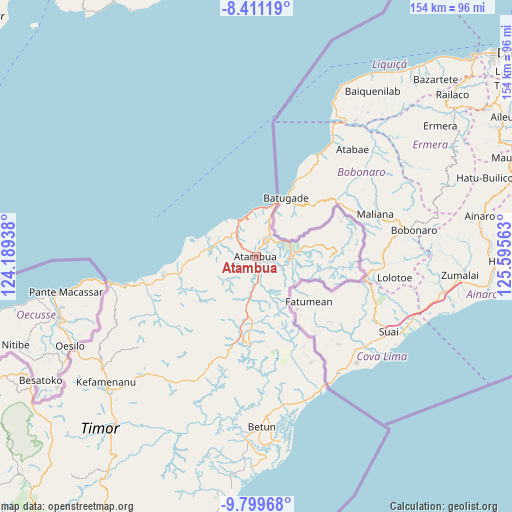
Atambua GPS coordinates[2]
9° 6' 21.996" South, 124° 53' 33" East
| Map corner | latitude | longitude |
|---|---|---|
| Upper-left | -8.41119°, | 124.18938° |
| Center: | -9.10611°, | 124.8925° |
| Lower-right: | -9.79968°, | 125.59563° |
| Map W x H: | 154.4×154.4 km | = 95.9×95.9mi |
| max Lat: | 5.88969° ⇑92.7% North |
| Atambua: | -9.10611° |
| min Lat: | ⇓7.3% South -10.934° |
| min Long | Atambua | max Long |
| 95.1345° | 124.8925° | 140.9419° |
| W 97.9%⇐ | ⇒2.1% E |
Elevation
Elevation of Atambua is 336 m = 1102 ft, and this is 106.3 m = 349 ft above average elevation for this country.
| Max E: |
3185 m = 10449 ft | 26.9% |
| Atambua | 336 m 1102 ft | |
| Avg. | 229.7 m = 754 ft | |
Min E: |
-1 m = -3 ft | 73.1% |
See also: Indonesia elevation on elevation.city.
Geographical zone
Atambua is located in South Torrid zone (between Equator and Tropic of Capricorn). Distance of Equator is 1012.5 km =629.1 mi to North.| Distance of | km | miles | from Atambua |
|---|---|---|---|
| Equator | 1012.5 | 629.1 | to North |
| Tropic Capricorn | 1593.4 | 990.1 | to South |
| Antarctic Circle | 6388.7 | 3969.8 | to South |
| South Pole | 8994.6 | 5589 | to South |


Nearby cities:
15 places around Atambua: (largest is in red/bold)
• Baanfaun
63.1 km =39.2 mi,  212°
212°
• Betun
51.3 km =31.9 mi,  178°
178°
• Biudukfoho
58.1 km =36.1 mi,  196°
196°
• Fatualam
58.1 km =36.1 mi,  220°
220°
• Kefamenanu
59.2 km =36.8 mi,  230°
230°
• Kiutoko
54.6 km =33.9 mi, 205°
• Leof
60.1 km =37.3 mi, 209°
• Malimaneek
59.1 km =36.7 mi, 196°
• Maurisu
58.1 km =36.1 mi, 206°
• Naiola
64.9 km =40.3 mi, 220°
• Neob
64.6 km =40.1 mi, 210°
• Nularan
61.7 km =38.3 mi, 203°
• Oeleno
59.7 km =37.1 mi, 196°
• Sasi
61.9 km =38.5 mi, 225°
• Wekmurak
54.1 km =33.6 mi, 200°
Sources, notices
• [Note1] Compared only with cities in Indonesia existing in our database
• [Src1] Map data: © OpenStreetMap contributors (CC-BY-SA)
• [Src2] Other city data from geonames.org with taken over terms of usage.
• [Src3] Geographical zone / Annual Mean Temperature by Robert A. Rohde @ Wikipedia
