Westport geodata
Westport (Connaught) is a populated place; located in Ireland in Europe/Dublin (GMT+1) time zone. With population of 6,200 people, there are 112 cities with bigger population in this country. Compared to other cities in Ireland, 81.8% of cities are located further ↓South; 96% of cities are located further →East and 77.2% of cities have higher elevation than Westport. Note1


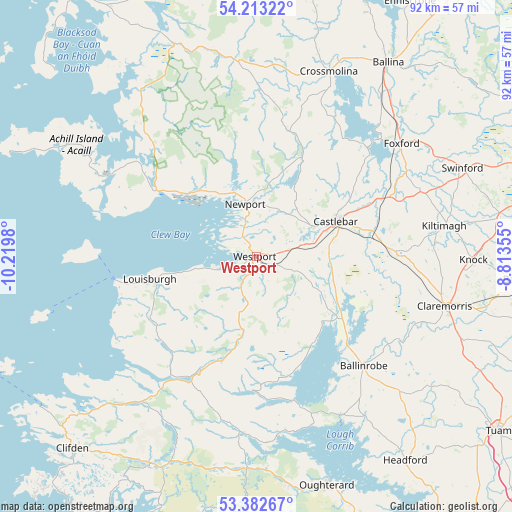
Westport GPS coordinates[2]
53° 48' 0" North, 9° 31' 0.012" West
| Map corner | latitude | longitude |
|---|---|---|
| Upper-left | 54.21322°, | -10.2198° |
| Center: | 53.8°, | -9.51667° |
| Lower-right: | 53.38267°, | -8.81355° |
| Map W x H: | 92.3×92.3 km | = 57.4×57.4mi |
| max Lat: | 55.25° ⇑18.2% North |
| Westport: | 53.8° |
| min Lat: | ⇓81.8% South 51.52487° |
| min Long | Westport | max Long |
| -10.26889° | -9.51667° | -6.04944° |
| W 4%⇐ | ⇒96% E |
Elevation
Elevation of Westport is 19 m = 62 ft, and this is 35.5 m = 116 ft below average elevation for this country.
| Max E: |
262 m = 860 ft | 77.2% |
| Avg. | 54.5 m = 179 ft | |
| Westport | 19 m = 62 ft | |
Min E: |
0 m = 0 ft | 22.8% |
See also: Ireland elevation on elevation.city.
Geographical zone
Westport is located in North temperate zone (between Tropic of Cancer and the Arctic Circle). Distance of this North polar circle is 1419.2 km =881.8 mi to North.| Distance of | km | miles | from Westport |
|---|---|---|---|
| North Pole | 4025.1 | 2501.1 | to North |
| Arctic Circle | 1419.2 | 881.8 | to North |
| Tropic Cancer | 3376.1 | 2097.8 | to South |
| Equator | 5982 | 3717 | to South |


Nearby cities:
15 places around Westport: (largest is in red/bold)
• Balla
25.5 km =15.8 mi,  89°
89°
• Ballina
42 km =26.1 mi,  33°
33°
• Ballinrobe
26.3 km =16.3 mi,  134°
134°
• Castlebar
15.3 km =9.5 mi,  68°
68°
• Claremorris
35.2 km =21.9 mi,  105°
105°
• Clifden
47.9 km =29.8 mi,  223°
223°
• Crossmolina
35.8 km =22.2 mi,  21°
21°
• Dooagh
44.4 km =27.6 mi,  295°
295°
• Foxford
33.1 km =20.6 mi,  52°
52°
• Headford
46.1 km =28.6 mi,  143°
143°
• Kiltamagh
34.4 km =21.4 mi,  80°
80°
• Knock
39.1 km =24.3 mi, 91°
• Newport
9.6 km =6 mi,  348°
348°
• Oughterard
44.3 km =27.5 mi,  164°
164°
• Swinford
40.7 km =25.3 mi, 65°
Sources, notices
• [Note1] Compared only with cities in Ireland existing in our database
• [Src1] Map data: © OpenStreetMap contributors (CC-BY-SA)
• [Src2] Other city data from geonames.org with taken over terms of usage.
• [Src3] Geographical zone / Annual Mean Temperature by Robert A. Rohde @ Wikipedia
