Kiltamagh geodata
Kiltamagh (Connaught) is a populated place; located in Ireland in Europe/Dublin (GMT+1) time zone. With population of 1,127 people, there are 326 cities with bigger population in this country. Compared to other cities in Ireland, 83.1% of cities are located further ↓South; 89.4% of cities are located further →East and 61.3% of cities have lower elevation than Kiltamagh. Note1


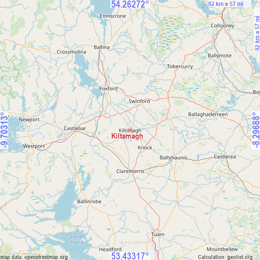
Kiltamagh GPS coordinates[2]
53° 51' 0" North, 9° 0' 0" West
| Map corner | latitude | longitude |
|---|---|---|
| Upper-left | 54.26272°, | -9.70313° |
| Center: | 53.85°, | -9° |
| Lower-right: | 53.43317°, | -8.29688° |
| Map W x H: | 92.2×92.2 km | = 57.3×57.3mi |
| max Lat: | 55.25° ⇑16.9% North |
| Kiltamagh: | 53.85° |
| min Lat: | ⇓83.1% South 51.52487° |
| min Long | Kiltamagh | max Long |
| -10.26889° | -9° | -6.04944° |
| W 10.6%⇐ | ⇒89.4% E |
Elevation
Elevation of Kiltamagh is 61 m = 200 ft, and this is 6.5 m = 21 ft above average elevation for this country.
| Max E: |
262 m = 860 ft | 38.7% |
| Kiltamagh | 61 m 200 ft | |
| Avg. | 54.5 m = 179 ft | |
Min E: |
0 m = 0 ft | 61.3% |
See also: Ireland elevation on elevation.city.
Geographical zone
Kiltamagh is located in North temperate zone (between Tropic of Cancer and the Arctic Circle). Distance of this North polar circle is 1413.6 km =878.4 mi to North.| Distance of | km | miles | from Kiltamagh |
|---|---|---|---|
| North Pole | 4019.5 | 2497.6 | to North |
| Arctic Circle | 1413.6 | 878.4 | to North |
| Tropic Cancer | 3381.6 | 2101.2 | to South |
| Equator | 5987.6 | 3720.5 | to South |


Nearby cities:
15 places around Kiltamagh: (largest is in red/bold)
• Balla
9.9 km =6.2 mi,  238°
238°
• Ballaghaderreen
27.9 km =17.3 mi,  78°
78°
• Ballina
31.6 km =19.6 mi,  339°
339°
• Ballinrobe
28.6 km =17.8 mi,  212°
212°
• Ballyhaunis
17.9 km =11.1 mi,  121°
121°
• Castlebar
19.7 km =12.2 mi,  270°
270°
• Castlerea
34.1 km =21.2 mi,  105°
105°
• Charlestown
18.5 km =11.5 mi,  46°
46°
• Claremorris
14.8 km =9.2 mi,  180°
180°
• Dunmore
31.3 km =19.4 mi,  145°
145°
• Foxford
16.4 km =10.2 mi,  332°
332°
• Knock
8.4 km =5.2 mi,  141°
141°
• Swinford
11.6 km =7.2 mi,  16°
16°
• Tobercurry
28.3 km =17.6 mi,  38°
38°
• Westport
34.4 km =21.4 mi,  260°
260°
Sources, notices
• [Note1] Compared only with cities in Ireland existing in our database
• [Src1] Map data: © OpenStreetMap contributors (CC-BY-SA)
• [Src2] Other city data from geonames.org with taken over terms of usage.
• [Src3] Geographical zone / Annual Mean Temperature by Robert A. Rohde @ Wikipedia
